
Europe Geographic Information System (GIS) Market Report Size, Share, Trends and Forecast by Component, Function, Device, End Use Industry, and Country, 2026-2034
Europe Geographic Information System (GIS) Market Size and Share:
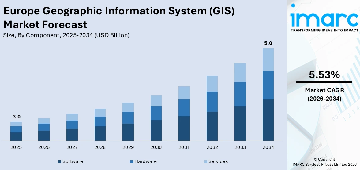
The Europe geographic information system (GIS) market size was valued at USD 3.0 Billion in 2025. The market is expected to reach USD 5.0 Billion by 2034, exhibiting a CAGR of 5.53% during 2026-2034. Germany currently dominates the market in 2025. The growth of the market is propelled by the growing requirement for spatial data analytics in industries like transportation and environmental management. In addition, accelerating growth in geospatial technology, such as cloud-based GIS platforms and real-time data integration, is improving efficiency in operations and decision-making. Apart from that, favorable government programs and infrastructure upgradation are further augmenting the Europe geographic information system (GIS) market share.
|
Report Attribute
|
Key Statistics
|
|---|---|
|
Base Year
|
2025
|
|
Forecast Years
|
2026-2034
|
|
Historical Years
|
2020-2025
|
| Market Size in 2025 | USD 3.0 Billion |
| Market Forecast in 2034 | USD 5.0 Billion |
| Market Growth Rate 2026-2034 | 5.53% |
The market is fueled by the growing smart city programs designed to streamline urban planning and resource management, as municipalities and governments look to improve operational efficiency through sophisticated spatial analytics. Additionally, the growing demand for environmental monitoring to support climate change, pollution control, and natural resource management is also propelling GIS deployment in the region. Apart from this, the increasing need for transportation and logistics optimization in Europe is compelling the adoption of GIS solutions to facilitate efficient route planning, real-time tracking of assets, and greater supply chain visibility. These solutions allow logistics providers to minimize operational costs, enhance delivery precision, and respond rapidly to dynamic market situations. Reflecting the trend, investments in the European logistics industry increased by 14% in 2024. This, in turn, is facilitating the implementation of cutting-edge GIS platforms.
To get more information on this market Request Sample
The accelerated growth of infrastructure projects, road networks, energy grids, and water delivery systems is driving market development. For example, in March 2025, Germany launched a massive infrastructure fund. The EUR 500 Billion to be distributed includes EUR 400 Billion for the federal government and EUR 100 Billion for federal states and municipalities over the next 12 years, with the aim of improving Germany's infrastructure. The share of the fund will finance projects in line with Germany's goal of carbon neutrality by 2045. In addition, one of the major Europe geographic information system (GIS) market trends is the increasing use of satellite imaging and remote sensing, which improves the accuracy and functions of GIS Platforms. Also, the European data deregulations are pushing organizations to develop protected geographic information systems to process sensitive location-based data. The growth of real-time GIS applications with the IoT is improving the overall decision-making process.
Europe Geographic Information System (GIS) Market Trends:
Development of Urban Infrastructures
The market is experiencing major growth with the widespread expansion of urban infrastructure. Governments and municipal councils are progressively implementing GIS solutions into urban development to maximize land use, improve transport systems, and enhance public utilities. In July 2025, the European Commission launched 94 transport infrastructure projects across the EU to be funded with almost USD 3.08 Billion under the Connecting Europe Facility (CEF). GIS technology facilitates sophisticated spatial analysis, allowing planners to display city plans, evaluate population density, and predict future growth trends more accurately. In smart city initiatives, GIS is critical in optimizing resources, tracking the environment, and supporting real-time decision-making. GIS also helps locate appropriate areas for new residential, commercial, or industrial projects, thereby ensuring urban growth is consistent with sustainability goals. The capacity of GIS to combine different data sets, including demographic, topographical, and infrastructural data, enables stakeholders to have a complete picture, leading to more effective, cost-saving, and eco-friendly urban development solutions for European metropolitan areas.
Escalating Need for Data Protection Pertaining to Logistics Management
Growth in the complexity of logistics functions across Europe has increased the need for strong GIS platforms with high-level data protection mechanisms. This, in turn, is driving the Europe geographic information system (GIS) market growth. As a result of geopolitical risks, the EU is looking into the creation of a new low-Earth orbit (LEO) satellite system to mitigate dependence on external assets. This estimated USD 540 Billion project highlights the strategic importance of geospatial technology in supporting European digital sovereignty, based on industry reports. With increasingly interconnected supply chains increasingly dependent on digital mapping technologies, the protection of location-based information has become a priority issue for business and regulatory authorities. GIS logistics applications contain sensitive data, like fleet routes, delivery schedules, and warehouse coordinates, which, if hacked, can cause operational interruptions and financial losses. Adherence to strict European data protection laws, like the General Data Protection Regulation (GDPR), also requires the implementation of GIS systems with robust encryption techniques and secure data-sharing structures. Organizations are increasingly putting money into GIS platforms that provide controlled access, real-time monitoring of threats, and preservation of data integrity. The trend is most notable in industries such as e-commerce, manufacturing, and cold-chain logistics, where accurate and secure geospatial data is critical to sustaining efficiency, reliability, and customer trust.
Integration of GIS with IoT and Real-Time Monitoring Systems
The integration of GIS with Internet of Things (IoT) devices and real-time monitoring systems is positively impacting the Europe geographic information system (GIS) market outlook. This convergence allows organizations to collect, process, and analyze geospatial data dynamically, enabling timely decision-making across multiple industries. Sensors embedded in transportation fleets, utilities infrastructure, and environmental monitoring stations transmit continuous location-based data to GIS platforms, creating a live geographic information network. This capability enhances situational awareness for applications such as traffic management, disaster response, and asset tracking. In agriculture, IoT-enabled GIS solutions are used to monitor soil moisture levels, weather patterns, and crop health, optimizing yield and resource use. The real-time aspect of GIS-IoT integration also supports predictive analytics, allowing stakeholders to anticipate and mitigate risks proactively. This trend is gaining momentum in Europe’s smart city initiatives and industrial automation projects, where precision, efficiency, and operational transparency are paramount.
.webp)
Europe Geographic Information System (GIS) Industry Segmentation:
IMARC Group provides an analysis of the key trends in each segment of the Europe geographic information system (GIS) market, along with forecasts at the regional and country levels from 2026-2034. The market has been categorized based on component, function, device, and end use industry.
Analysis by Component:
- Hardware
- Software
- Services
Software leads the market with around 45.2% of market share in 2025. The segment fuels innovations and improves the functionality of GIS solutions for different sectors. Advanced GIS software has seen a high demand from its immense applications in urban planning, environmental monitoring, transport, and agriculture. GIS software is utilized by European companies to analyze location-based data, enhance decision-making, and streamline resource management. Major market players both provide proprietary and open-source solutions to meet varied needs, ranging from government organizations to businesses. Cloud-based platforms and the integration of AI are revolutionizing the way GIS software is used, processing data more efficiently and facilitating real-time decision-making. With Europe shifting towards smart cities and green practices, GIS software becomes essential in handling intricate geographic data and enforcing digital transformation across sectors.
Analysis by Function:
- Mapping
- Surveying
- Telematics and Navigation
- Location-Based Services
Mapping leads the market with around 50.2% of market share in 2025. The segment forms the basis for visualization and analysis of spatial data. Mapping enables users to generate detailed and accurate maps that denote geographical features, land use, infrastructure, and environmental information. Mapping in Europe plays a critical role across industries like urban planning, disaster planning, environmental protection, and transport. It enables decision-makers to recognize patterns, examine trends, and make informed decisions. The accelerated use of mapping tools has been fueled by technological advances, such as satellite imaging, GPS, and cloud-based services, which facilitate more accurate and real-time mapping. As Europe's cities expand and environmental issues increase, mapping tools in GIS platforms are becoming essential for sustainable development, resource management, and effective planning. The significance of mapping in GIS is that it can transform complicated spatial information into understandable, actionable knowledge for a variety of sectors.
Analysis by Device:
- Desktop
- Mobile
Desktop leads the market with around 61% of market share in 2025. The segment acts as a powerful platform for GIS experts to conduct intricate spatial analysis and mapping operations. Desktop GIS applications provide high capability, including sophisticated data processing, modeling, and visualization, which are necessary in urban planning, environmental monitoring, and infrastructural management in Europe. The significance of desktop lies in their capability to process extensive data sets, execute advanced algorithms, and maintain high-resolution images, which are best for intricate geographic studies. They ensure users have a secure and stable environment, especially in sectors that need data secrecy and high processing power. Despite the growth in cloud-based and mobile applications, desktop GIS devices remain popular for their adaptability, reliability, and compatibility to be used in tandem with other specialized hardware and equipment. With the growth in the GIS market in Europe, desktop devices will remain a central part of data-driven GIS processes.
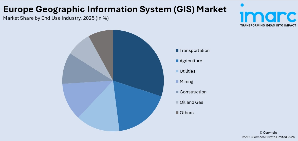
Analysis by End Use Industry:
Access the comprehensive market breakdown Request Sample
- Agriculture
- Utilities
- Mining
- Construction
- Transportation
- Oil and Gas
- Others
Transportation leads the market with around 25.5% of market share in 2025. GIS is important in the optimization of transport systems through analysis and management of traffic movement, route optimization, and the planning of infrastructure. Due to increasing emphasis on smart cities and sustainable means of transportation, transport agencies in Europe heavily depend on GIS in terms of increasing efficiency, decreasing congestion, and improving safety. GIS facilitates real-time monitoring of transport networks, predictive maintenance of infrastructure, and planning new projects from spatial data. In addition, GIS technology allows various modes of transport to be integrated more effectively, making multimodal transit solutions smoother. As Europe increasingly turns towards cleaner transport options and digitalization, GIS will be a critical tool for enhancing transport efficiency, curbing environmental footprints, and improving overall system resilience.
Country Analysis:
- Germany
- France
- United Kingdom
- Italy
- Spain
- Others
In 2025, Germany is at the forefront as a lead developer and adopter of GIS technology. Moreover, the focus on digitalization and infrastructure renewal has made GIS as a crucial tool across all sectors, such as urban planning, transportation, environmental management, and utilities. In addition to this, German businesses and government institutions utilize GIS for enhancing city planning, tracking environmental factors, and operational management of transport networks. GIS in Germany also leverages the integration with other technologies such as artificial intelligence (AI), machine learning (ML), and internet of things (IoT) to improve data analysis and real-time decision-making. With its status as the biggest economy in Europe, German innovation boosts GIS applications, further enhancing the regional market growth. The country's interest in sustainability and smart city projects again highlights the value of GIS in developing more efficient, resilient, and sustainable urban environments.
Competitive Landscape:
The market is characterized by the presence of varied players providing solutions ranging from sophisticated spatial analytics to cloud-based GIS environments. In addition, market players are concentrating on technologic innovation, integration with AI and IoT, and improved user interfaces to address the changing needs of industries like transportation, agriculture, defense, and urban planning. Further, strategic alliances, mergers, and acquisitions are popular strategies to increase geographic reach and enhance product offerings. Competitiveness continues to rely on service differentiation, data accuracy, and real-time processing ability. Vendors are also making investments in localized solutions to meet region-specific regulatory needs and language preferences. As per the Europe geographic information system (GIS) market forecast, the growing trend towards SaaS and subscription-based GIS models will heighten competition, with increasing focus on data security, cost efficiency, and scalability. Overall, the market indicates a competitive landscape characterized by innovation, customization, and strategic partnerships.
The report provides a comprehensive analysis of the competitive landscape in the Europe geographic information system (GIS) market with detailed profiles of all major companies.
Latest News and Developments:
- June 2025: The Czech city of Orlová developed an open-source GIS portal to enhance urban planning and climate adaptation. Built in-house, it offered thematic maps on energy efficiency, schools, and the environment. Future versions aimed to integrate sensor data and promote data transparency, innovation, and educational use across municipalities.
- June 2025: The Open Cadastral Map added five new countries, Belgium, Estonia, Ireland, Croatia, and Switzerland bringing the total to 15 European nations. The update is part of the Open Maps for Europe 2 (OME2) project, running until the end of 2025, which aims to harmonize cadastral data for easier access. The initiative, co-funded by the European Union, is led by EuroGeographics and other national agencies. A pan-European Cadastral Data Strategy is also set to be finalized by 2025.
Europe Geographic Information System (GIS) Market Report Scope:
| Report Features | Details |
|---|---|
| Base Year of the Analysis | 2025 |
| Historical Period | 2020-2025 |
| Forecast Period | 2026-2034 |
| Units | Billion USD |
|
Scope of the Report
|
Exploration of Historical and Forecast Trends, Industry Catalysts and Challenges, Segment-Wise Historical and Predictive Market Assessment:
|
| Components Covered | Hardware, Software, Services |
| Functions Covered | Mapping, Surveying, Telematics and Navigation, Location-Based Services |
| Devices Covered | Desktop, Mobile |
| End Use Industries Covered | Agriculture, Utilities, Mining, Construction, Transportation, Oil and Gas, Others |
| Countries Covered | Germany, France, United Kingdom, Italy, Spain, Others |
| Customization Scope | 10% Free Customization |
| Post-Sale Analyst Support | 10-12 Weeks |
| Delivery Format | PDF and Excel through Email (We can also provide the editable version of the report in PPT/Word format on special request) |
Key Benefits for Stakeholders:
- IMARC’s report offers a comprehensive quantitative analysis of various market segments, historical and current market trends, market forecasts, and dynamics of the Europe geographic information system (GIS) market from 2020-2034.
- The research study provides the latest information on the market drivers, challenges, and opportunities in the Europe geographic information system (GIS) market.
- Porter's Five Forces analysis assists stakeholders in assessing the impact of new entrants, competitive rivalry, supplier power, buyer power, and the threat of substitution. It helps stakeholders to analyze the level of competition within the Europe geographic information system (GIS) industry and its attractiveness.
- Competitive landscape allows stakeholders to understand their competitive environment and provides an insight into the current positions of key players in the market.
Frequently Asked Questions About the Europe Geographic Information System (GIS) Market Report
The geographic information system (GIS) market in Europe was valued at USD 3.0 Billion in 2025.
The Europe geographic information system (GIS) market is projected to exhibit a CAGR of 5.53% during 2026-2034, reaching a value of USD 5.0 Billion by 2034.
The market is driven by the increasing demand for spatial data in urban planning, environmental management, and infrastructure development. Additionally, advancements in cloud computing, IoT, and AI technologies enhance GIS capabilities. Growing government investments in smart city initiatives and environmental monitoring further propel market growth, with an increasing focus on sustainability.
Software dominates the component segment in the market in 2025 due its ability to provide advanced data analysis, visualization, and mapping capabilities. The rise of cloud-based GIS solutions, coupled with the growing need for real-time decision-making and data-driven insights, boosts the demand for GIS software across industries like urban planning, transportation, and agriculture.
Need more help?
- Speak to our experienced analysts for insights on the current market scenarios.
- Include additional segments and countries to customize the report as per your requirement.
- Gain an unparalleled competitive advantage in your domain by understanding how to utilize the report and positively impacting your operations and revenue.
- For further assistance, please connect with our analysts.
 Request Customization
 Speak to an Analyst
 Request Brochure
 Inquire Before Buying
Benefits of Customization
- Personalize this research
- Triangulate with your data
- Get data as per your format and definition
- Gain a deeper dive into a specific application, geography, customer, or competitor
- Any level of personalization
Get in Touch With Us
UNITED STATES
Phone: +1-201-971-6302
INDIA
Phone: +91-120-433-0800
UNITED KINGDOM
Phone: +44-753-714-6104
Email: [email protected]
Client Testimonials


.webp)


