
India Geographic Information System (GIS) Market Size, Share, Trends and Forecast by Component, Function, Device, End Use Industry, and Region, 2026-2034
Market Overview:
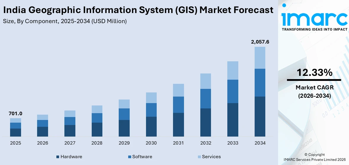
The India geographic information system (GIS) market size reached USD 701.0 Million in 2025. Looking forward, IMARC Group expects the market to reach USD 2,057.6 Million by 2034, exhibiting a growth rate (CAGR) of 12.33% during 2026-2034.
|
Report Attribute
|
Key Statistics
|
|---|---|
|
Base Year
|
2025
|
|
Forecast Years
|
2026-2034
|
|
Historical Years
|
2020-2025
|
| Market Size in 2025 | USD 701.0 Million |
| Market Forecast in 2034 | USD 2,057.6 Million |
| Market Growth Rate (2026-2034) | 12.33% |
The geographic information system (GIS) gathers, manages, and examines data related to different positions on the earth’s surface. It relies on integrated data formats, such as digital, cartographic and photographic data, to offer a better understanding of topographical information. It is widely being adopted for disaster management and mitigation, rerouting design, mapping, landslide hazard zonation, accident analysis, transportation planning, environmental impact surveys, and navigation.
To get more information on this market Request Sample
Rapid urbanization, coupled with the increasing need for advanced solutions in the agriculture, military, real estate, and transportation sectors, represents one of the primary factors strengthening the GIS market in India. Moreover, as GIS provides better insights into spatial patterns and relationships to the engineers and architects, its adoption is increasing in the country to allow better decision-making and improve management performances. Apart from this, governing agencies are heavily investing in the development of smart cities, which is positively influencing the adoption of GIS for urban planning across the country.
Key Market Segmentation:
IMARC Group provides an analysis of the key trends in each sub-segment of the India geographic information system (GIS) market report, along with forecasts at the country and regional level from 2026-2034. Our report has categorized the market based on component, function, device and end use industry.
Breakup by Component:
- Hardware
- Software
- Services
Breakup by Function:
- Mapping
- Surveying
- Telematics and Navigation
- Location-Based Services
Breakup by Device:
- Desktop
- Mobile
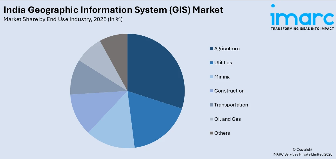
Breakup by End Use Industry:
Access the comprehensive market breakdown Request Sample
- Agriculture
- Utilities
- Mining
- Construction
- Transportation
- Oil and Gas
- Others
Breakup by Region:
- North India
- West and Central India
- South India
- East India
Competitive Landscape:
The competitive landscape of the industry has also been examined along with the profiles of the key players.
Report Coverage:
| Report Features | Details |
|---|---|
| Base Year of the Analysis | 2025 |
| Historical Period | 2020-2025 |
| Forecast Period | 2026-2034 |
| Units | Million USD |
| Segment Coverage | Component, Function, Device, End Use Industry, Region |
| Region Covered | North India, West and Central India, South India, East India |
| Customization Scope | 10% Free Customization |
| Post-Sale Analyst Support | 10-12 Weeks |
| Delivery Format | PDF and Excel through Email (We can also provide the editable version of the report in PPT/Word format on special request) |
Frequently Asked Questions About the India Geographic Information System (GIS) Market Report
The India geographic information system (GIS) market was valued at USD 701.0 Million in 2025.
We expect the India geographic information system (GIS) market to exhibit a CAGR of 12.33% during 2026-2034.
The growing adoption of advanced solutions across various sectors, including agriculture, military, real estate, transportation, etc., is currently driving the India geographic information system (GIS) market.
The sudden outbreak of the COVID-19 pandemic has led to the rising demand for geographic information system (GIS) for locating virus hotspots and mapping infection to mitigate the risk of disease transmission.
Based on the component, the India geographic information system (GIS) market can be divided into hardware, software, and services. Currently, software holds the majority of the total market share.
Based on the function, the India geographic information system (GIS) market has been segregated into mapping, surveying, telematics and navigation, and location-based services. Among these, mapping currently exhibits a clear dominance in the market.
Based on the device, the India geographic information system (GIS) market can be categorized into desktop and mobile. Currently, desktop accounts for the majority of the total market share.
Based on the end use industry, the India geographic information system (GIS) market can be segmented into agriculture, utilities, mining, construction, transportation, oil and gas, and others. Amongst these, the transportation industry currently accounts for the largest market share.
On a regional level, the market has been classified into North India, West and Central India, South India, and East India, where West and Central India currently dominates the Indian market.
Need more help?
- Speak to our experienced analysts for insights on the current market scenarios.
- Include additional segments and countries to customize the report as per your requirement.
- Gain an unparalleled competitive advantage in your domain by understanding how to utilize the report and positively impacting your operations and revenue.
- For further assistance, please connect with our analysts.
 Request Customization
 Speak to an Analyst
 Request Brochure
 Inquire Before Buying
Benefits of Customization
- Personalize this research
- Triangulate with your data
- Get data as per your format and definition
- Gain a deeper dive into a specific application, geography, customer, or competitor
- Any level of personalization
Get in Touch With Us
UNITED STATES
Phone: +1-201-971-6302
INDIA
Phone: +91-120-433-0800
UNITED KINGDOM
Phone: +44-753-714-6104
Email: [email protected]
Client Testimonials


.webp)


