
Geographic Information System (GIS) Market Report by Component (Hardware, Software, Services), Function (Mapping, Surveying, Telematics and Navigation, Location-Based Services), Device (Desktop, Mobile), End Use Industry (Agriculture, Utilities, Mining, Construction, Transportation, Oil and Gas, and Others), and Region 2026-2034
Global Geographic Information System (GIS) Market:
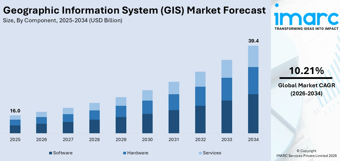
The global geographic information system (GIS) market size reached USD 16.0 Billion in 2025. Looking forward, IMARC Group expects the market to reach USD 39.4 Billion by 2034, exhibiting a growth rate (CAGR) of 10.21% during 2026-2034. The increasing demand for advanced solutions across the transportation, real estate, military, and agriculture sectors represents one of the primary factors bolstering the market.
|
Report Attribute
|
Key Statistics
|
|---|---|
|
Base Year
|
2025
|
|
Forecast Years
|
2026-2034
|
|
Historical Years
|
2020-2025
|
|
Market Size in 2025
|
USD 16.0 Billion |
|
Market Forecast in 2034
|
USD 39.4 Billion |
| Market Growth Rate 2026-2034 | 10.21% |
Geographic Information System Market Analysis:
- Major Market Drivers: The increasing investments by government bodies in smart cities to gain a better insight into geospatial patterns are fueling the market. Additionally, the expanding applications of GIS in the healthcare sector are also acting as significant growth-inducing factors.
- Key Market Trends: The rising popularity of automated vehicles, along with the growing penetration of IoT-based devices, is positively influencing the usage of geographic information systems in altering road closures, route planning, traffic management, in-car navigation predicting traffic, etc.
- Geographical Trends: North America exhibits a clear dominance in the global market, owing to the escalating demand for GIS in telecom enterprises to enhance communication and customer services. Moreover, the introduction of spatial data analytics technologies is further stimulating the regional market.
- Competitive Landscape: According to the geographic information system market overview, some of the prominent companies include Autodesk Inc., Caliper Corporation, Environmental Systems Research Institute Inc., Hexagon AB, L3Harris Technologies, Inc., Maxar Technologies Inc, Seequent, SuperMap Software Co. Ltd., Topcon Positioning Systems, Inc., and Trimble Inc., among many others.
- Challenges and Opportunities: One of the primary challenges includes the need to ensure the quality and accuracy of the data used. GIS systems extensively rely on accurate information for analysis. Inaccuracies in data can lead to errors in decision-making. However, the development of geospatial artificial intelligence (GeoAI) that adopts AI to extract information from spatial big data is projected to stimulate the market in the coming years.
To get more information on this market Request Sample
Geographic Information System Market Trends:
Need for Emergency Management
The rising concerns among regulatory authorities towards public safety are elevating the usage of a geographic information system, as it aids in providing precise spatial data that help officials to make informed decisions during crises. For example, in October 2023, CentralSquare Technologies, one of the industry leaders in public sector technology, announced a partnership with DATAMARK, the public safety geographic information systems (GIS) team of Michael Baker International. CentralSquare’s partnership with DATAMARK assisted public safety agencies in realizing the potential of their GIS mapping data to plan, prepare, and respond better to emergency incidents by using the most accurate location-based information available. Moreover, the rising situational awareness and the inflating need for mapping events, such as natural disasters, are also bolstering the geographic information system market growth. For instance, Virtual Louisiana, rebuilt by the Louisiana Governor’s Office of Homeland Security and Emergency Preparedness (GOHSEP) with geographic information system (GIS) technology, contains comprehensive data on disasters. The site includes information on evacuation routes and shelter locations, real-time weather forecasts, and a way for residents to report damage to their homes. Besides this, the increasing focus on evacuation planning to analyze routes and identify safe zones is further catalyzing the global market. For example, in February 2024, Ryan Kinsella, an intern with the Office of Emergency Management and graduate student in the Geography Department at Binghamton University, launched a series of interactive public safety maps to provide accessible information easily to limit confusion during crises.
Technological Advancements
The development of numerous innovations in geographic information systems has significantly expanded their capabilities and applications. One of the most notable advancements is the integration of artificial intelligence (AI) and machine learning (ML). Additionally, several organizations across the globe are pairing location intelligence with AI to make accurate business predictions, automate tasks, gain insights from large amounts of data, etc. For instance, FedEx's global logistics operation extensively relies on extreme precision. To keep deliveries on time, FedEx utilizes the novel enterprise GIS to track its fleet. Moreover, AI's predictive capabilities aid in identifying when a plane would need parts or maintenance, making a complex supply chain on schedule and more efficient. This, in turn, is propelling the geographic information system market demand. Apart from this, the emerging trend of cloud computing by key players to provide flexible, scalable, and cost-effective GIS solutions is further strengthening the market. For example, in April 2024, the National Aeronautics and Space Administration (NASA) and its Marshall Space Flight Center in Huntsville procured capability statements from interested parties for its Innovative Visualization, Exploration and Data Analysis (IVEDA) acquisition. In line with this, it is focused on introducing new dashboard instances of NASA's Visualization, Exploration, and Data Analysis (VEDA) Platform to support the agency's Earth Science Data System (ESDS) Program. Apart from this, in July 2023, ROK Technologies, a trusted GIS-managed cloud services provider, and Schneider Electric, one of the global leaders in the digital transformation of energy management and automation, announced a partnership to deliver a comprehensive managed services offering to utilities to migrate ArcGIS and ArcFM systems to the cloud.
Rising Mobile GIS Applications
Continuous advancements in mobile technology and the easy availability of smartphones and tablets are increasing the adoption of mobile-based geographic information systems. They find widespread usage in numerous fields, such as urban planning, environmental conservation, emergency services, etc., where the ability to make swift, informed decisions can be critical. This, in turn, represents the geographic information system market opportunities. For instance, in July 2023, TP Southern Odisha Distribution Limited (TPSODL), a subsidiary of Tata Power Company Limited that operates as a power distribution company in the southern region of Odisha, India, launched a new mobile application specifically designed for updating geographical information system. Moreover, users can easily search for assets based on asset code, address, work ID, or location via the GIS mobile app. Apart from this, the flexibility and convenience of mobile GIS also foster greater collaboration among teams, as data can be shared and accessed by anyone, anywhere, at any time, facilitating more dynamic and responsive project management. For example, in May 2023, Leica Geosystems, part of Hexagon, announced the introduction of its Leica Pegasus TRK portfolio of mobile mapping solutions, the Leica Pegasus TRK100. Specifically designed for GIS professionals, this novel mobile mapping system is an easy-to-use geospatial solution built for digital twin creation and large-scale infrastructure measurement.
Geographic Information System Market Segmentation:
IMARC Group provides an analysis of the key trends in each segment of the market, along with the geographic information system market forecast at the global, regional, and country levels for 2026-2034. Our report has categorized the market based on the component, function, device, and end use industry.
Breakup by Component:
- Hardware
- Software
- Services
Software holds the largest market share
The report has provided a detailed breakup and analysis of the market based on the component. This includes hardware, software and services. According to the report, software represented the largest segmentation.
Software solutions that combine GIS mapping, geospatial data, and advanced environmental analytics enable organizations to make various types of weather-related data actionable. In line with this, GIS software enables strategic business decisions in areas such as delivery management and transportation, real estate portfolio management, customer segmentation, etc. Moreover, it is gaining extensive traction in sustainable farming by providing accurate and comprehensive data. For instance, the Soil & Water Assessment Tool (SWAT) developed by IBM and Texas A&M AgriLife aids in enhancing crop management strategies. Apart from this, according to the geographic information system market statistics, continuous collaborations among key players will continue to fuel the growth in this segmentation over the forecasted period. For example, in July 2023, VertiGIS, one of the leading solution providers and software developers in the field of geographic information systems (GIS) and spatial asset management, acquired ibR Gesellschaft für Geoinformation mbH (ibR) to serve its expanding customer base.
Breakup by Function:
- Mapping
- Surveying
- Telematics and Navigation
- Location-Based Services
At present, telematics and navigation exhibits a clear dominance in the market
The report has provided a detailed breakup and analysis of the market based on the function. This includes mapping, surveying, telematics and navigation, and location-based services. According to the report, telematics and navigation represented the largest market segmentation.
The escalating demand for location-based services and real-time tracking is propelling the geographic information system market revenue in this segmentation. In telematics, GIS helps to optimize fleet management by analyzing traffic patterns, vehicle movements, road conditions, etc., thereby allowing for dynamic route planning and scheduling. For instance, in July 2023, CompassCom Software launched Version 8.2 of the CompassCom GIS-centric hybrid telematics platform that can be deployed in the cloud or on-premises for real-time asset tracking and comprehensive fleet management. In addition to this, it also enables navigation systems to provide up-to-date maps, driving directions, and traffic updates to users.
Breakup by Device:
- Desktop
- Mobile
Currently, desktop accounted for the largest geographic information system market share
The report has provided a detailed breakup and analysis of the market based on the device. This includes desktop and mobile. According to the report, desktop represented the largest market segmentation.
Desktop GIS software, like QGIS and ArcGIS, provides individuals with the ability to edit, create, and analyze spatial data in a robust and customizable environment. Its offline capabilities are particularly valuable in remote areas or locations with limited internet connectivity. Moreover, desktop GIS solutions offer extensive support for spatial analysis techniques, including spatial querying, buffering, and overlay operations. For example, in July 2023, Trimble introduced the Trimble Terra Office add-in for Esri ArcGIS Pro. The add-in is part of Trimble's Terra Office suite of desktop solutions for integrating TerraFlex field data collection software with GIS systems of record.
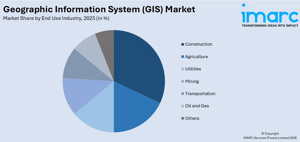
Breakup by End Use Industry:
Access the comprehensive market breakdown Request Sample
- Agriculture
- Utilities
- Mining
- Construction
- Transportation
- Oil and Gas
- Others
Among these, construction accounts for the majority of the market share
The report has provided a detailed breakup and analysis of the market based on the end use industry. This includes agriculture, utilities, mining, construction, transportation, oil and gas and others. According to the report, construction represented the largest market segmentation.
Geographic information systems find extensive applications in the construction industry for enhancing project management, planning, and decision-making processes. Moreover, GIS enables construction professionals to analyze spatial data such as land use, topography, and infrastructure, facilitating informed site selection, and feasibility studies. This, in turn, increases the geographic information system market revenue. For example, in December 2021, Genesys International, one of the pioneers in survey mapping and 3D content, launched its pan India program to make the Digital Twin of cities across the country. In line with this, in March 2023, GPRS introduced SiteMap, a GIS-for-construction platform.
Breakup by Region:
- North America
- United States
- Canada
- Asia Pacific
- China
- Japan
- India
- South Korea
- Australia
- Indonesia
- Others
- Europe
- Germany
- France
- United Kingdom
- Italy
- Spain
- Russia
- Others
- Latin America
- Brazil
- Mexico
- Others
- Middle East and Africa
North America exhibits a clear dominance in the market
The market research report has also provided a comprehensive analysis of all the major regional markets, which include North America (the United States and Canada); Asia Pacific (China, Japan, India, South Korea, Australia, Indonesia, and others); Europe (Germany, France, the United Kingdom, Italy, Spain, Russia, and others); Latin America (Brazil, Mexico, and others); and the Middle East and Africa. According to the report, North America accounted for the largest market share.
For state and local government agencies in countries, such as the U.S., across North America, geographic information system technology is utilized to inform decision-making, impact funding, and improve the constituent experience through several applications. According to Arturo Tovar, the GIS supervisor for the Housing and Community Development Department (HCD) in Houston, after Hurricane Harvey, GIS played an important role in obtaining the necessary funding to get individuals in the city back into their homes. In addition to this, the increasing number of GIS user groups in the United States that are an enhanced way to participate in the exchange of ideas, knowledge, and experiences related to GIS software, analysis, and data management through workshops, regular meetings, online forums, etc., is positively influencing the geographic information system market outlook across the country. Some of the common GIS user groups include the Arizona Geographic Information Council (AGIC), Bay Area Automated Mapping Association, North Bay GIS User Group, etc. Furthermore, the introduction of innovative mapping and spatial data analytics technologies is expected to fuel the regional market over the forecasted period.
Competitive Landscape:
The market research report has provided a comprehensive analysis of the competitive landscape. Detailed profiles of all major geographic information system market companies have also been provided. Some of the key players in the market include:
- Autodesk Inc.
- Caliper Corporation
- Environmental Systems Research Institute Inc.
- Hexagon AB
- L3Harris Technologies, Inc.
- Maxar Technologies Inc
- Seequent
- SuperMap Software Co. Ltd.
- Topcon Positioning Systems, Inc.
- Trimble Inc.
(Please note that this is only a partial list of the key players, and the complete list is provided in the report.)
Geographic Information System Market Recent Developments:
- March 2024: Agribazaar, an agritech platform and a member of the StarAgri group, introduced an AI-driven geographic information system (GIS) based command center in Lucknow, India. This initiative is part of the crop survey project by the Uttar Pradesh Diversified Agriculture Support Project (UPDASP).
- January 2024: The Esri India and Centre for Knowledge Sovereignty (CKS) announced the launch of the Master Mentors Geo-enabling Indian Scholars (MMGEIS) program to enable more patents from India to become a global geospatial innovation hub.
- January 2024: Tourism Minister of Kerela, P.A. Mohamed Riyas, developed the Geographic Information System (GIS)-based mapping project of the Kozhikode Corporation.
Geographic Information System Market Report Scope:
| Report Features | Details |
|---|---|
| Base Year of the Analysis | 2025 |
| Historical Period | 2020-2025 |
| Forecast Period | 2026-2034 |
| Units | Billion USD |
| Scope of the Report | Exploration of Historical Trends and Market Outlook, Industry Catalysts and Challenges, Segment-Wise Historical and Future Market Assessment:
|
| Components Covered | Hardware, Software, Services |
| Functions Covered | Mapping, Surveying, Telematics and Navigation, Location-Based Services |
| Devices Covered | Desktop, Mobile |
| End Use Industries Covered | Agriculture, Utilities, Mining, Construction, Transportation, Oil and Gas, Others |
| Regions Covered | Asia Pacific, Europe, North America, Latin America, Middle East and Africa |
| Countries Covered | United States, Canada, Germany, France, United Kingdom, Italy, Spain, Russia, China, Japan, India, South Korea, Australia, Indonesia, Brazil, Mexico |
| Companies Covered | Autodesk Inc., Caliper Corporation, Environmental Systems Research Institute Inc., Hexagon AB, L3Harris Technologies, Inc., Maxar Technologies Inc, Seequent, SuperMap Software Co. Ltd., Topcon Positioning Systems, Inc., Trimble Inc., etc. |
| Customization Scope | 10% Free Customization |
| Post-Sale Analyst Support | 10-12 Weeks |
| Delivery Format | PDF and Excel through Email (We can also provide the editable version of the report in PPT/Word format on special request) |
Key Benefits for Stakeholders:
- IMARC’s report offers a comprehensive quantitative analysis of various market segments, historical and current market trends, market forecasts, and dynamics of the geographic information system market from 2020-2034.
- The research study provides the latest information on the market drivers, challenges, and opportunities in the global geographic information system market.
- The study maps the leading as well as the fastest growing regional markets. It further enables stakeholders to identify the key country-level markets within each region.
- Porter's five forces analysis assist stakeholders in assessing the impact of new entrants, competitive rivalry, supplier power, buyer power, and the threat of substitution. It helps stakeholders to analyze the level of competition within the geographic information system industry and its attractiveness.
- Competitive landscape allows stakeholders to understand their competitive environment and provides an insight into the current positions of key players in the market.
Frequently Asked Questions About the Geographic Information System (GIS) Market Report
The global geographic information system (GIS) market was valued at USD 16.0 Billion in 2025.
According to the estimates by IMARC Group, the global geographic information system (GIS) market is expected to exhibit a CAGR of 10.21% during 2026-2034.
The increasing utilization of GIS in the agriculture sector for precision farming, soil mapping, and analyzing crop productivity represents one of the key drivers for the global geographic information system (GIS) market.
The advent of geospatial artificial intelligence (GeoAI) that uses AI to extract information from spatial big data represents one of the key trends in the global geographic information system (GIS) market.
Sudden outbreak of the COVID-19 pandemic has resulted in the extensive utilization of geographic information system (GIS) to formulate resource strategies for COVID-19 affected regions through its facility of storing spatial data.
On the basis of the component, the market has been classified into hardware, software and services. Among these, software holds the largest market share.
On the basis of the function, the market has been bifurcated into mapping, surveying, telematics and navigation, and location-based services. At present, telematics and navigation exhibits a clear dominance in the market.
On the basis of the device, the market has been classified into desktop and mobile. Currently, the desktop represents the largest segment.
On the basis of the end use industry, the market has been segmented into agriculture, utilities, mining, construction, transportation, oil and gas and others. Among these, construction accounts for the majority of the market share.
Region-wise, the market has been classified into North America, Europe, Asia Pacific, Middle East and Africa, and Latin America, where North America dominates the global market.
The key companies in the global geographic information system (GIS) market are Autodesk Inc., Caliper Corporation, Environmental Systems Research Institute Inc., Hexagon AB, L3Harris Technologies, Inc., Maxar Technologies Inc, Seequent, SuperMap Software Co. Ltd., Topcon Positioning Systems, Inc. and Trimble Inc.
Need more help?
- Speak to our experienced analysts for insights on the current market scenarios.
- Include additional segments and countries to customize the report as per your requirement.
- Gain an unparalleled competitive advantage in your domain by understanding how to utilize the report and positively impacting your operations and revenue.
- For further assistance, please connect with our analysts.
 Request Customization
 Speak to an Analyst
 Request Brochure
 Inquire Before Buying
Benefits of Customization
- Personalize this research
- Triangulate with your data
- Get data as per your format and definition
- Gain a deeper dive into a specific application, geography, customer, or competitor
- Any level of personalization
Get in Touch With Us
UNITED STATES
Phone: +1-201-971-6302
INDIA
Phone: +91-120-433-0800
UNITED KINGDOM
Phone: +44-753-714-6104
Email: [email protected]
Client Testimonials


.webp)


