
Remote Sensing Software Market Report by Component (Software, Services), Deployment Mode (On-premises, Cloud-based), Application (Ground, Satellite, Airborne), End User (Defense, Commercial), and Region 2026-2034
Global Remote Sensing Software Market:
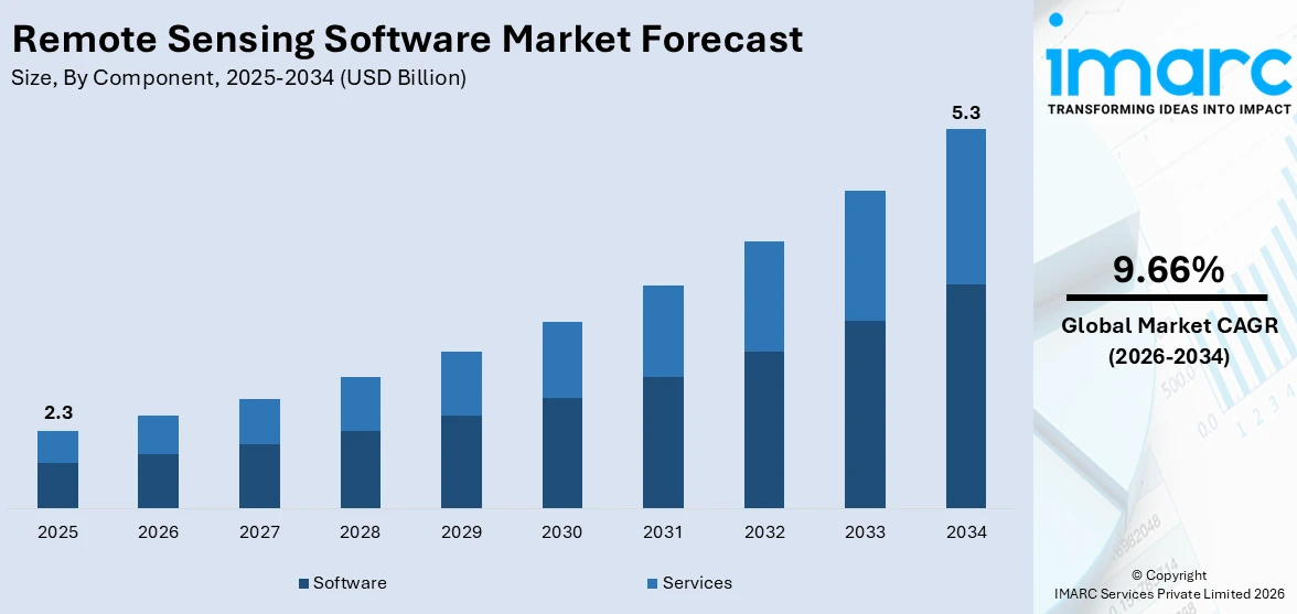
The global remote sensing software market size reached USD 2.3 Billion in 2025. Looking forward, IMARC Group expects the market to reach USD 5.3 Billion by 2034, exhibiting a growth rate (CAGR) of 9.66% during 2026-2034. The growing demand for accurate data in agriculture and urban planning is stimulating the market.
|
Report Attribute
|
Key Statistics
|
|---|---|
|
Base Year
|
2025
|
|
Forecast Years
|
2026-2034
|
|
Historical Years
|
2020-2025
|
|
Market Size in 2025
|
USD 2.3 Billion |
|
Market Forecast in 2034
|
USD 5.3 Billion |
| Market Growth Rate 2026-2034 | 9.66% |
Remote Sensing Software Market Analysis:
- Major Market Drivers: The rising environmental concerns are leading to increased use of this software to manage natural resources, thereby propelling the market.
- Key Market Trends: The increase in government spending on defense and surveillance systems is creating demand for precise imaging solutions, which is acting as a significant growth-inducing factor.
- Competitive Landscape: Some of the major market companies include BAE Systems, EOS Data Analytics, Inc., Esri, Hexagon AB, Merrick & Company, NV5 Geospatial Solutions, Inc., Perspective Geomatics, Rolta India Limited, Textron Systems, and Trimble Inc., among many others.
- Geographical Trends: North America exhibits a clear dominance in the market due to strong investment in defense, agriculture, and environmental monitoring, along with advanced technological infrastructure and government support.
- Challenges and Opportunities: The high initial costs and technical complexity are hindering the market. However, offering affordable cloud-based solutions and user-friendly interfaces to broaden accessibility will continue to strengthen the market over the forecast period.
To get more information on this market Request Sample
Remote Sensing Software Market Trends:
Increasing Adoption of Open-source Tools
Open-source tools are becoming essential in remote sensing software, which provides accessible and customizable solutions for various applications. Moreover, these tools reduce costs for organizations and facilitate collaboration, leading to faster innovation. Also, this adoption expands the availability of advanced remote sensing technologies for diverse industries, further driving remote sensing software market growth. For instance, in May 2024, Permian Global launched 'rsi,' an open-source software package designed to improve remote sensing analysis of biomass and land-use change. It enables efficient satellite imagery processing, which is developed for the R programming language streamlining workflows for Landsat and Sentinel data analysis.
Advancements in High-resolution Data Processing
The demand for higher accuracy in remote sensing applications is driving advancements in high-resolution data processing. In contrast, enhanced software capabilities allow for more detailed analysis of environmental factors, enabling better decision-making in areas like agriculture, urban planning, and disaster management. Furthermore, these developments are improving data interpretation and operational efficiency. For instance, in August 2024, India initiated GNSS-Reflectometry via the EOS-08 satellite, utilizing algorithms from SAC-ISRO for processing GNSS signals reflected off Earth's surfaces. This innovation enables remote sensing of soil moisture, surface inundation, and ocean conditions, thereby improving high-resolution data analysis for scientific applications.
Growing use of AI-powered Models
Artificial intelligence is increasingly integrated into remote sensing software, which is offering improved accuracy in data analysis and automation. In addition, AI-powered models enhance pattern recognition and predictive capabilities, thereby allowing for faster processing of large datasets. Furthermore, this trend is enabling more effective monitoring and management of complex environmental and industrial systems. For instance, in September 2024, China launched "RingMo 3.0," the world's first large-scale remote sensing basic model with over 10 billion parameters, which was unveiled at the Aerospace Information Technology Conference. Furthermore, the model enhances the extraction and processing of remote sensing data, boosting data utilization efficiency.
Global Remote Sensing Software Industry Segmentation:
IMARC Group provides an analysis of the key trends in each segment of the market, along with the market forecast at the global, regional, and country levels for 2026-2034. Our report has categorized the market based on component, deployment mode, application, and end user.
Breakup by Component:
- Software
- Services
Software currently holds the largest remote sensing software market share
The report has provided a detailed breakup and analysis of the market based on the component. This includes software and services. According to the report, software represented the largest market segmentation.
Software leads the remote sensing market because of its role in processing and analyzing large datasets. For instance, ESRI's ArcGIS offers advanced remote sensing capabilities, which enhance decision-making for various sectors like agriculture and urban planning through satellite data analysis.
Breakup by Deployment Mode:
- On-premises
- Cloud-based
On-premises currently dominates the market
The report has provided a detailed breakup and analysis of the market based on the deployment mode. This includes on-premises and cloud-based. According to the report, on-premises represented the largest market segmentation.
On-premises deployment dominates the market, offering enhanced data security and control, which is important for industries like defense and agriculture. For example, Hexagon’s ERDAS IMAGINE, widely used in geospatial applications, offers robust on-premises capabilities for processing satellite imagery and remote sensing data.
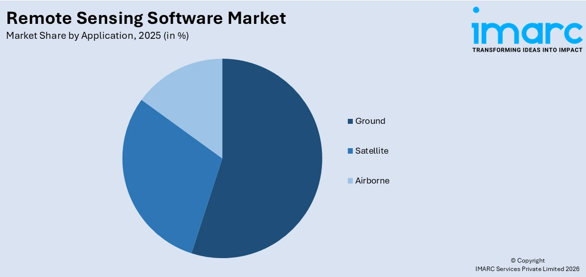
Breakup by Application:
Access the comprehensive market breakdown Request Sample
- Ground
- Satellite
- Airborne
Ground currently dominates the market
The report has provided a detailed breakup and analysis of the market based on the application. This includes ground, satellite, and airborne. According to the report, ground represented the largest market segmentation.
Ground-based applications exhibit a clear dominance in the market, offering precise, real-time data collection for environmental monitoring and land use analysis. For example, Trimble’s eCognition software supports advanced ground-level data processing for forestry and agriculture applications, thereby enhancing decision-making accuracy.
Breakup by End User:
- Defense
- Commercial
Defense currently holds the largest remote sensing software market share
The report has provided a detailed breakup and analysis of the market based on the end user. This includes defense and commercial. According to the report, defense represented the largest market segmentation.
Defense dominates the market due to its need for high-resolution imagery and real-time intelligence. For example, L3Harris Geospatial’s ENVI software is widely used by defense agencies for analyzing satellite and aerial data to support military operations.
Breakup by Region:
- North America
- United States
- Canada
- Asia-Pacific
- China
- Japan
- India
- South Korea
- Australia
- Indonesia
- Others
- Europe
- Germany
- France
- United Kingdom
- Italy
- Spain
- Russia
- Others
- Latin America
- Brazil
- Mexico
- Others
- Middle East and Africa
North America currently dominates the market
The market research report has also provided a comprehensive analysis of all the major regional markets, which include North America (the United States and Canada); Asia Pacific (China, Japan, India, South Korea, Australia, Indonesia, and others); Europe (Germany, France, the United Kingdom, Italy, Spain, Russia, and others); Latin America (Brazil, Mexico, and others); and the Middle East and Africa. According to the report, North America accounted for the largest remote sensing software market share.
North America dominates the market, which is driven by advanced technological infrastructure and high investment in sectors like defense, agriculture, and environmental monitoring. In contrast, the region's dominance is bolstered by strong government initiatives and private-sector innovation. For instance, Harris Corporation launched ENVI remote sensing software, widely used for analyzing geospatial data in the defense and intelligence sectors. Furthermore, the region's focus on satellite data utilization and sophisticated software solutions strengthens its leadership in the global market.
Competitive Landscape:
The market research report has provided a comprehensive analysis of the competitive landscape. Detailed profiles of all market companies have also been provided. Some of the key players in the market include:
- BAE Systems
- EOS Data Analytics, Inc.
- Esri
- Hexagon AB
- Merrick & Company
- NV5 Geospatial Solutions, Inc.
- Perspective Geomatics
- Rolta India Limited
- Textron Systems
- Trimble Inc.
(Please note that this is only a partial list of the key players, and the complete list is provided in the report.)
Remote Sensing Software Market Recent Developments:
- September 2024: China launched "RingMo 3.0," the world's first large-scale remote sensing software basic model with over 10 billion parameters, which was unveiled at the Aerospace Information Technology Conference.
- August 2024: India initiated GNSS-Reflectometry via the EOS-08 satellite, utilizing algorithms from SAC-ISRO for processing GNSS signals reflected off Earth's surfaces. This innovation enables remote sensing of soil moisture, surface inundation, and ocean conditions, thereby improving high-resolution data analysis for scientific applications.
- May 2024: Permian Global launched 'rsi,' an open-source software package designed to improve remote sensing analysis of biomass and land-use change.
Remote Sensing Software Market Report Scope:
| Report Features | Details |
|---|---|
| Base Year of the Analysis | 2025 |
| Historical Period | 2020-2025 |
| Forecast Period | 2026-2034 |
| Units | Billion USD |
| Scope of the Report | Exploration of Historical Trends and Market Outlook, Industry Catalysts and Challenges, Segment-Wise Historical and Predictive Market Assessment:
|
| Components Covered | Software, Services |
| Deployment Modes Covered | On-premises, Cloud-based |
| Applications Covered | Ground, Satellite, Airborne |
| End Users Covered | Defense, Commercial |
| Regions Covered | Asia Pacific, Europe, North America, Latin America, Middle East and Africa |
| Countries Covered | United States, Canada, Germany, France, United Kingdom, Italy, Spain, Russia, China, Japan, India, South Korea, Australia, Indonesia, Brazil, Mexico |
| Companies Covered | BAE Systems, EOS Data Analytics, Inc., Esri, Hexagon AB, Merrick & Company, NV5 Geospatial Solutions, Inc., Perspective Geomatics, Rolta India Limited, Textron Systems, Trimble Inc., etc. |
| Customization Scope | 10% Free Customization |
| Post-Sale Analyst Support | 10-12 Weeks |
| Delivery Format | PDF and Excel through Email (We can also provide the editable version of the report in PPT/Word format on special request) |
Key Benefits for Stakeholders:
- IMARC's industry report offers a comprehensive quantitative analysis of various market segments, historical and current market trends, market forecasts, and dynamics of the remote sensing software market from 2020-2034.
- The research report provides the latest information on the market drivers, challenges, and opportunities in the global remote sensing software market.
- The study maps the leading, as well as the fastest-growing, regional markets. It further enables stakeholders to identify the key country-level markets within each region.
- Porter's five forces analysis assists stakeholders in assessing the impact of new entrants, competitive rivalry, supplier power, buyer power, and the threat of substitution. It helps stakeholders to analyze the level of competition within the remote sensing software industry and its attractiveness.
- The competitive landscape allows stakeholders to understand their competitive environment and provides insight into the current positions of key players in the market.
Frequently Asked Questions About the Remote Sensing Software Market Report
The global remote sensing software market size was valued at USD 2.3 Billion in 2025.
We expect the global remote sensing software market to exhibit a CAGR of 9.66% during 2026-2034.
The rising adoption of remote sensing software across numerous industries, such as healthcare, commercial, military, etc., to instantly interpret the data and forecast natural hazards is primarily driving the global remote sensing software market.
The sudden outbreak of the COVID-19 pandemic has led to increasing demand for remote sensing software as it enables epidemiologists to map the coronavirus infection against different parameters, such as demographics, geographies, environment, etc., to understand its spread pattern and intensity.
Based on the component, the global remote sensing software market has been segmented into software and services. Currently, software holds the majority of the total market share.
Based on the deployment mode, the global remote sensing software market can be divided into on- premises and cloud-based, where on-premises deployment currently exhibits a clear dominance in the market.
Based on the application, the global remote sensing software market has been categorized into ground, satellite, and airborne. Among these, ground accounts for the majority of the global market share.
Based on the end user, the global remote sensing software market can be segregated into defense and commercial. Currently, the defense sector holds the largest market share.
On a regional level, the market has been classified into North America, Asia-Pacific, Europe, Latin America, and Middle East and Africa, where North America currently dominates the global market.
Some of the major players in the global remote sensing software market include BAE Systems, EOS Data Analytics, Inc., Esri, Hexagon AB, Merrick & Company, NV5 Geospatial Solutions, Inc., Perspective Geomatics, Rolta India Limited, Textron Systems, and Trimble Inc.
Need more help?
- Speak to our experienced analysts for insights on the current market scenarios.
- Include additional segments and countries to customize the report as per your requirement.
- Gain an unparalleled competitive advantage in your domain by understanding how to utilize the report and positively impacting your operations and revenue.
- For further assistance, please connect with our analysts.
 Request Customization
 Speak to an Analyst
 Request Brochure
 Inquire Before Buying
Benefits of Customization
- Personalize this research
- Triangulate with your data
- Get data as per your format and definition
- Gain a deeper dive into a specific application, geography, customer, or competitor
- Any level of personalization
Get in Touch With Us
UNITED STATES
Phone: +1-201-971-6302
INDIA
Phone: +91-120-433-0800
UNITED KINGDOM
Phone: +44-753-714-6104
Email: [email protected]
Client Testimonials


.webp)


