
Satellite Data Service Market Size, Share, Trends and Forecast by Service, Application, Vertical, and Region, 2026-2034
Satellite Data Service Market Size and Share:
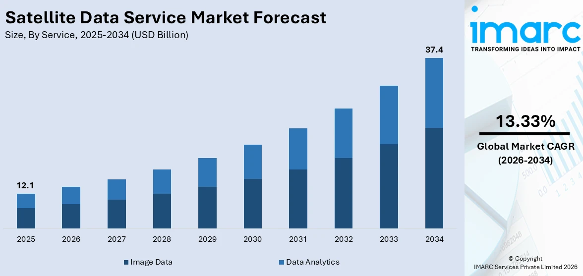
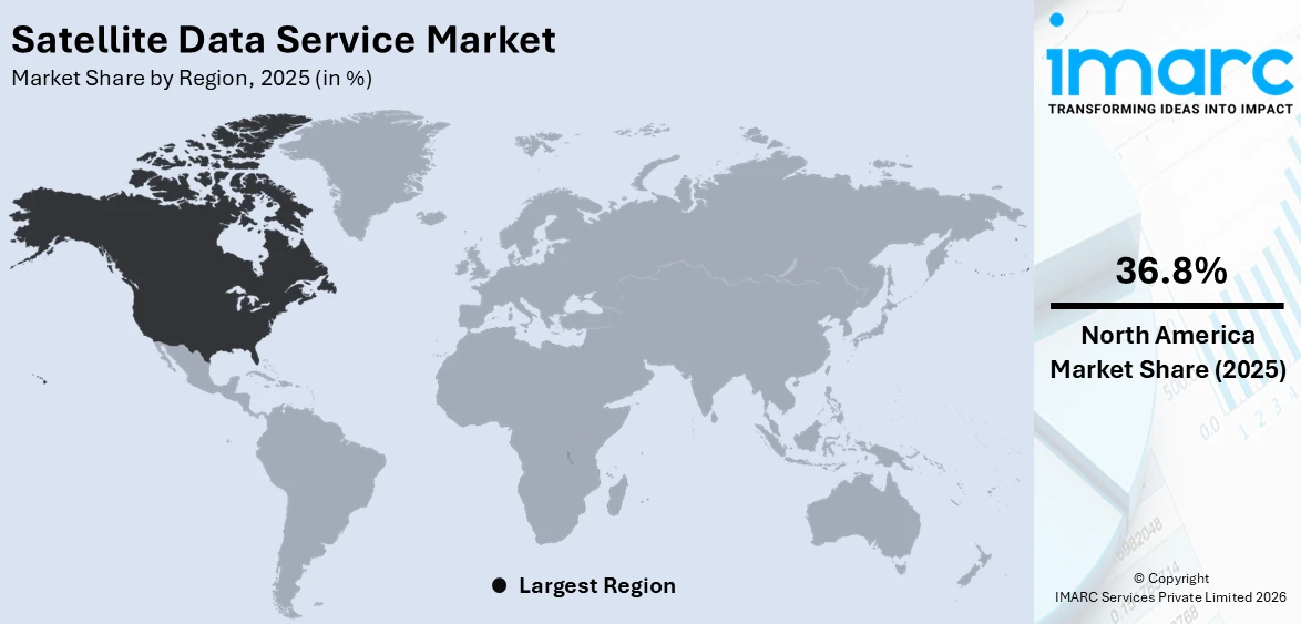
The global satellite data service market size reached USD 12.1 Billion in 2025. Looking forward, IMARC Group expects the market to reach USD 37.4 Billion by 2034, exhibiting a growth rate (CAGR) of 13.33% during 2026-2034. North America currently dominates the market with a 36.8% share of the market in 2025. This region’s dominance is driven by advanced infrastructure, significant investments in satellite technologies, strong industrial demand, and extensive applications across defense, agriculture, and environmental monitoring.
|
Report Attribute
|
Key Statistics
|
|---|---|
|
Base Year
|
2025
|
|
Forecast Years
|
2026-2034
|
|
Historical Years
|
2020-2025
|
|
Market Size in 2025
|
USD 12.1 Billion |
|
Market Forecast in 2034
|
USD 37.4 Billion |
| Market Growth Rate (2026-2034) | 13.33% |
One major drivers of the satellite data service market is the increasing demand for real-time, high-resolution geospatial data across various industries. As sectors, such as agriculture, defense, energy, and logistics, prioritize data-driven decision-making, satellite-based services offer unparalleled insights for monitoring, planning, and operational efficiency. Advancements in satellite technology, including enhanced imaging capabilities and data transmission speeds, further bolster the adoption of these services. For instance, in 2024, Planet Labs signed a multi-million-dollar contract extension with a U.S.-allied government agency for its SkySat high-resolution satellite data, offering imagery with 50 cm resolution and multiple daily revisits. The SkySat fleet will be replaced by the next-gen Pelican satellites, enhancing revisit rates, resolution, and latency. Planet’s collaboration with NVIDIA integrates AI edge processing for Pelican-2, launching later this year, to accelerate customer insights. Additionally, the growing reliance on satellite data for climate monitoring and disaster management underscores its critical role in addressing global challenges. This trend is supported by expanding investments in satellite infrastructure and data analytics platforms.
To get more information on this market Request Sample
The United States is a key player in the satellite data service market, leveraging its advanced technology and robust space infrastructure. Leading companies are providing high-resolution geospatial data, serving diverse sectors including agriculture, defense, and environmental monitoring. The U.S. government supports the industry through initiatives like NASA’s Earth Science Division and NOAA’s satellite programs, fostering innovation and ensuring data accessibility. Collaboration between private firms and federal agencies accelerates advancements in satellite imaging and analytics. For instance, in 2024, Maxar Intelligence and Satellogic announced an agreement enhancing Maxar’s near real-time monitoring capabilities, offering 30 cm-class imagery to deliver cost-effective, high-resolution Earth observation data with improved revisit frequency. Additionally, the growing demand for climate monitoring and disaster response data underscores the U.S.’s pivotal role in the market.
Satellite Data Service Market Trends:
Advancements in Satellite Technology
The market is tremendously influenced by rapid advancements in satellite technology. These developments include improvements in satellite miniaturization, higher-resolution imaging capabilities, and increased data transmission speeds. According to the Satellite Industry Association’s (SIA) annual report, the global satellite industry grew revenue by 2% in 2023, as most segments of the industry except satellite TV saw gains. The advent of small satellites, such as CubeSats and nano-satellites, has reduced the cost of satellite missions, making space-based data services more accessible to a broader range of users. Additionally, enhanced imaging technology enables more detailed earth observation and remote sensing, catering to various industries like farming, ecological assessment, and city development. Furthermore, advancements in data analytics and machine learning have expanded the potential applications, driving market growth.
Expanding Commercial Applications
The market is experiencing robust growth due to expanding commercial applications across diverse industries. Businesses in sectors such as agriculture, insurance, and logistics increasingly rely on it for precision farming, risk assessment, and supply chain monitoring. In agriculture, satellite imagery aids in monitoring crop health, soil conditions, and water resources, optimizing crop yield and resource usage. In insurance, it assists in assessing property damage from natural disasters, streamlining claims processing. In addition, the logistics and transportation sectors utilize it for route optimization and monitoring assets. This widespread commercial adoption is propelled by the data's accuracy, timeliness, and the ability to cover vast, remote areas, driving market expansion. In terms of launches, 2023 sets a new record with 221 launches globally, which is 19% more than the previous record of 185 launches achieved in 2022, as per the report by European Space Policy Institute. A new record high of 2,889 satellites were launched in a single year in 2020, which confirmed the trend that had begun that year and was 16% higher than in 2022. Most of these launches were for commercial applications.
Government and Defense Initiatives
Government and defense initiatives are major drivers of the market. National space agencies and defense departments heavily invest in its applications such as border surveillance, environmental monitoring, and national security. Governments use satellite imagery for urban planning, disaster management, and climate change studies, making critical contributions to public policy and safety. The defense sector's reliance on high-resolution imagery for intelligence, surveillance, and reconnaissance missions also fuels demand. Furthermore, international collaborations and public-private partnerships in space missions stimulate technological innovations and market growth, as governments seek to leverage private sector expertise and resources in satellite technology. This government and defense sector investment underscores the strategic importance, bolstering the market's expansion. One such glorious example is India. The Indian government has started a number of projects that use satellite imagery to design infrastructure and conduct efficient governance. For instance, the Digital India initiative uses satellite data for project management and monitoring to make India a digitally enabled nation. The Department of Space (DoS), which remains the backbone of the nation's space program and oversees carrying out a number of expensive projects, has been given INR 12,544 crore (USD 1.48 Billion) in the Union Budget for 2023–2024.
Satellite Data Service Industry Segmentation:
IMARC Group provides an analysis of the key trends in each segment of the global satellite data service market, along with forecast at the global, regional, and country levels for 2026-2034. Our report has categorized the market based on service, application, and vertical.
Analysis by Service:
- Data Analytics
- Image Data
Image data leads the market with around 75.6% of the market share in 2025. The image data segment focuses mainly on the provision of raw and processed imagery captured by satellites. This segment is mainly for industries that require highly detailed images of the Earth's surface for applications including environmental monitoring, military reconnaissance, and infrastructure development. Demand in this segment mainly comes from the enhanced satellite capabilities to capture detailed images covering wide geographical areas. Moreover, improvements in imaging technologies, such as multispectral and hyperspectral imaging, are increasing the scope and quality of satellite data services. Therefore, it is now an indispensable requirement for proper and accurate earth observation. Image data services are very important for immediate applications such as disaster response and management and long-term monitoring and planning in agriculture, forestry, and urban development.
Analysis by Application:
Access the comprehensive market breakdown Request Sample
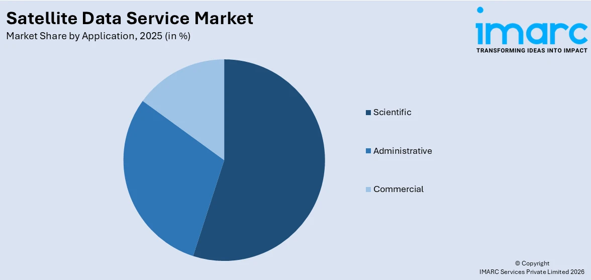
- Scientific
- Administrative
- Commercial
The scientific application segment in the market is primarily driven by the need for data in earth and space sciences. This segment is used for various research purposes, including climate change studies, atmospheric monitoring, oceanography, and geology. Scientific applications often require high-precision data to monitor and understand natural processes and phenomena. This information is very important for model development, which will be used in predicting weather patterns, assessing environmental changes, and understanding planetary dynamics. This section is funded by national space agencies, research institutions, and international collaborations that are involved in scientific exploration and discovery.
It is used in the administrative application segment by governmental and international agencies for multiple purposes of administrative and regulatory work. Some of its uses are land use planning, urban development, infrastructure management, border control, and disaster management. It offers the governments a facility for efficiently monitoring vast and oftentimes remote areas with information updated in time for significant decision-making processes. This segment is critical for good governance and public administration because it aids in the implementation of policies, monitoring of compliance, and assessment of public infrastructure.
The commercial application segment is growing at a faster pace due to the wide diversity of various industries like agriculture, real estate, insurance, and logistics. It is applied in agriculture to adopt precision farming techniques and to monitor crop health, managing resources. In real estate and insurance, it is used for property assessment and risk management. In the logistics sector, it is applied for route planning and fleet management. This segment is also benefited through broad availability and increasing affordability, enabling businesses of any size to utilize space-based insights to gain competitive advantages.
Analysis by Vertical:
- Defence and Security
- Energy and Power
- Agriculture
- Environmental
- Engineering and Infrastructure
- Marine
- Others
Environmental lead the market in 2025. The environmental segment uses it for monitoring and managing natural resources and ecosystems. This includes tracking deforestation, monitoring wildlife habitats, assessing the impacts of climate change, and observing oceanic and atmospheric changes. It provides unparalleled insights into environmental conditions across the globe. By providing accurate, real-time data, it supports informed decision-making for environmental protection, sustainability efforts, and addressing climate challenges, solidifying its importance in safeguarding the planet's natural ecosystems.
Regional Analysis:
To get more information on the regional analysis of this market Request Sample
- North America
- United States
- Canada
- Asia Pacific
- China
- Japan
- India
- South Korea
- Australia
- Indonesia
- Others
- Europe
- Germany
- France
- United Kingdom
- Italy
- Spain
- Russia
- Others
- Latin America
- Brazil
- Mexico
- Others
- Middle East and Africa
In 2025, North America accounted for the largest market share of over 36.8%. This dominance is attributed to the region's advanced technological infrastructure, robust industrial base, and significant investments in research and development. Key industries, including aerospace, defense, and energy, heavily rely on innovative solutions, driving demand and market growth. Additionally, the presence of leading manufacturers and a favorable regulatory environment further bolster North America's position. The region's focus on sustainability and adoption of advanced technologies ensures continued leadership in the market, reinforcing its role as a critical contributor to global industry advancements.
Key Regional Takeaways:
United States Satellite Data Service Market Analysis
The US accounts for 83.4% of the market share in North America. The growing need for Earth observation and remote sensing applications across sectors including agriculture, defense, energy, and transportation is the main factor propelling the US satellite data services market. Satellite data gathering and processing have advanced because of the government's significant investments in space technologies, which are best represented by NASA's missions and partnerships with private businesses like SpaceX. One of the biggest users of satellite data, the U.S. defense industry, uses the technology for intelligence gathering, mission planning, and surveillance, which greatly propels market expansion. Through the creation of CubeSats and small satellites, which lower operating costs and improve data accessibility, the private sector is also promoting growth. Businesses like Maxar Technologies and Planet Labs are developing their high-resolution imagery and geospatial analytics skills to meet business demands like infrastructure monitoring and disaster relief. As per the reports by U.S. International Trade Commission, 11.5% of private expenditure in space was allocated to space launches during 2018-2022. 87% of launch-specific investment and half of all private investment in space comes from U.S. corporations. Furthermore, the use of satellite data in environmental monitoring and climate research supports national sustainability and catastrophe preparedness objectives, increasing its usefulness even further. Decision-making is improved by the growing integration of artificial intelligence (AI) and machine learning (ML) for satellite data analysis, which places the United States at the forefront of this sector.
Europe Satellite Data Service Market Analysis
The European Space Agency (ESA) and state programs that encourage innovation in space technologies have made Europe a major player in the market for satellite data services. The European Union's Earth observation program, Copernicus, provides free satellite data for use in emergency response, agriculture, urban planning, and climate monitoring. European satellites offer useful information that is publicly and freely accessible every day. 34 petabytes of data on land, water, ice, and air have been gathered thus far by the Copernicus program's Sentinel satellites and other missions. Since then, more than 600,000 people have used this. Europe is becoming a pioneer in using satellite data for environmental sustainability because to these projects. Private businesses, like as Airbus and OHB SE, are growing their presence in the satellite data services market to serve industries like maritime, oil and gas, and transportation. The need for satellite-based solutions is being driven by the expansion of smart cities and renewable energy projects throughout Europe, which mostly rely on geospatial data for planning and optimization.
The potential of the European market is further increased by the integration of satellite data with 5G networks and IoT applications, which is emerging as a key area of concentration and promises improved connection and real-time analytics.
Asia Pacific Satellite Data Service Market Analysis
The market for satellite data services is expanding rapidly in Asia-Pacific due to increased funding for space initiatives and technological breakthroughs. The region is being led by nations like China, India, and Japan. The need for satellite data has increased because of the multiple satellites launched by China's CNSA and India's ISRO to aid in agricultural monitoring, disaster relief, and Earth observation. Geospatial data is essential for effective planning and resource management because of the fast urbanization and infrastructure development in nations like India and Southeast Asia. Satellite data is also increasingly being used for environmental monitoring, especially to address climatic issues like pollution and deforestation. With their frequent satellite launches, Asian nations are emerging as industry leaders. The second set of 18 satellites for the proposed 14,000-satellite Thousand Sails mega constellation, for example, was successfully launched by China recently. Furthermore, 1,296 satellites are planned for the constellation's initial phase by Shanghai Spacecom Satellite Technology (SSST) of China. By the end of 2025, 648 of these are expected to be deployed to offer regional network coverage. More than 14,000 broadband multimedia satellites in low Earth orbit will make up the finished network.
Latin America Satellite Data Service Market Analysis
Due to its significance in tackling regional issues including urban development, illegal mining, and deforestation, the satellite data service business in Latin America is expanding. Governments in nations like Mexico and Brazil are using satellite data to handle disasters and monitor the environment. As an illustration of the technology's usefulness, Brazil uses satellite data to monitor the Amazon jungle and fight illicit logging. Satellite data is being used more and more by the agriculture industry, which contributes significantly to the region's economy, for weather forecasting and precision farming. Collaborations with commercial companies and international space organisations are also improving the availability of sophisticated satellite data, which is propelling market growth in Latin America. Given how important internet services are, businesses in this area are always looking to increase their capacity and offer better satellite services. For this reason, Orbith, an Argentine satellite internet provider, is working to guarantee that every person and company in Latin America has access to reasonably priced, fast internet. In order to lower the cost of internet for its clientele in Argentina, Chile, and shortly, Paraguay, the company recently announced its agreement with Astranis for a MicroGEO satellite that will launch in 2025. Further, Intelsat (multinational satellite services provider) is also pouring more resources into Latin America. In 2023, Intelsat invested upwards of USD 100 Million to build additional capacity and launch new services in Brazil, which included the buildout of an existing teleport facility in Rio de Janeiro to deliver connectivity services to more users across the region.
Middle East and Africa Satellite Data Service Market Analysis
Applications in crisis management, oil and gas, and agriculture are driving the market for satellite data services in the Middle East and Africa. Particularly in dry areas, satellite data is essential for tracking water scarcity and improving resource management. Leading the way in space technology investments are the United Arab Emirates and Saudi Arabia, which use satellite data for infrastructure development and urban planning. Furthermore, major corporations are investing, combining with other organizations, and funding new initiatives in an effort to expand their customer base overall and better satisfy their needs across a range of applications. For example, the UAE's leading satellite solutions provider, Al Yah Satellite Communications Company PJSC (Yahsat), and Bayanat, a provider of artificial intelligence (AI)-powered geospatial solutions, announced in May 2023 a comprehensive Space Program primarily aimed at developing national satellite remote sensing and Earth observation capabilities within the UAE primarily to commercially address the key business opportunities in the global and local Earth observation market. Africa is becoming more and more dependent on satellite data for disaster relief, climate monitoring, and agricultural output. Access to data services is being made possible by international partnerships and affordable satellite initiatives, which is stimulating regional market expansion.
Competitive Landscape:
The satellite data service market is characterized by intense competition, driven by innovation and technological advancements. Key players dominate through cutting-edge imaging capabilities, robust analytics platforms, and extensive satellite networks. Emerging companies focus on niche applications, such as environmental monitoring and urban planning, enhancing market dynamics. Strategic partnerships, mergers, and acquisitions further intensify the competition, as companies aim to expand their capabilities and market reach. The competitive landscape is also influenced by government contracts, defense applications, and the growing demand for real-time geospatial intelligence. For instance, in 2024, NASA, through the CSDA Program, secured Airbus SAR and WorldDEM access, enabling high-resolution, all-weather radar data from Airbus’ constellation to enhance Earth science research and NASA-ISRO initiatives with advanced monitoring capabilities.
The report provides a comprehensive analysis of the competitive landscape in the satellite data service market with detailed profiles of all major companies, including:
- Airbus SE
- Ceinsys Tech Limited
- Geospatial Intelligence Pyt. Ltd.
- Gisat S.R.O.
- ICEYE
- L3harris Technologies Inc.
- Maxar Technologies Inc.
- Planet Labs Inc.
- Satellite Imaging Corporation
- Telstra Corporation Limited
- Trimble Inc.
- Ursa Space Systems Inc.
Recent Developments:
- December 2024: The Meteosat-12, the first of EUMETSAT's Meteosat Third Generation (MTG) geostationary satellites, is now fully operational. It significantly and favourably improves the community's capacity to forecast extreme weather and track climate change, according to the World Meteorological Organisation.
- May 2024: The Indian government has authorized NewSpace India Limited (NSIL) to exclusively manage all data and products from the Indian Remote Sensing (IRS) satellites. This decision is intended to enhance the commercialization of satellite data and streamline its distribution for diverse applications like agriculture, urban planning, and disaster management. NSIL’s central role in handling IRS data aligns with India’s broader goals to boost its space economy and ensure efficient access to geospatial intelligence.
- December 2023: L3harris Technologies Inc. announced a strategic partnership with L3Harris to work together to develop and bring quantum radio frequency (RF) sensing technologies from the laboratory to the field.
- August 2023: Airbus SE, BMW Group, and Quantinuum created a hybrid quantum-classical workflow to accelerate future research on fuel cell catalyst chemical processes utilizing quantum computers to model quantum systems.
- March 2023: ICEYE announced that it will take part in a parametric trial program designed to prevent floods in low-income areas of New York City.
Satellite Data Service Market Report Scope:
| Report Features | Details |
|---|---|
| Base Year of the Analysis | 2025 |
| Historical Period | 2020-2025 |
| Forecast Period | 2026-2034 |
| Units | Billion USD |
| Scope of the Report | Exploration of Historical Trends and Market Outlook, Industry Catalysts and Challenges, Segment-Wise Historical and Future Market Assessment:
|
| Services Covered | Data Analytics, Image Data |
| Applications Covered | Scientific, Administrative, Commercial |
| Verticals Covered | Defence and Security, Energy and Power, Agriculture, Environmental, Engineering and Infrastructure, Marine, Others |
| Regions Covered | Asia Pacific, Europe, North America, Latin America, Middle East and Africa |
| Countries Covered | United States, Canada, Germany, France, United Kingdom, Italy, Spain, Russia, China, Japan, India, South Korea, Australia, Indonesia, Brazil, Mexico |
| Companies Covered | Airbus SE, Ceinsys Tech Limited, Geospatial Intelligence Pyt. Ltd., Gisat S.R.O., ICEYE, L3harris Technologies Inc., Maxar Technologies Inc., Planet Labs Inc., Satellite Imaging Corporation, Telstra Corporation Limited, Trimble Inc., Ursa Space Systems Inc., etc. |
| Customization Scope | 10% Free Customization |
| Post-Sale Analyst Support | 10-12 Weeks |
| Delivery Format | PDF and Excel through Email (We can also provide the editable version of the report in PPT/Word format on special request) |
Key Benefits for Stakeholders:
- IMARC’s industry report offers a comprehensive quantitative analysis of various market segments, historical and current market trends, satellite data service market forecast, and dynamics of the market from 2020-2034.
- The research report provides the latest information on the market drivers, challenges, and opportunities in the global satellite data service market.
- The study maps the leading, as well as the fastest-growing, regional markets. It further enables stakeholders to identify the key country-level markets within each region.
- Porter's five forces analysis assists stakeholders in assessing the impact of new entrants, competitive rivalry, supplier power, buyer power, and the threat of substitution. It helps stakeholders to analyze the level of competition within the satellite data service industry and its attractiveness.
- The competitive landscape allows stakeholders to understand their competitive environment and provides insight into the current positions of key players in the market.
Frequently Asked Questions About the Satellite Data Service Market Report
A satellite data service provides access to information collected by satellites, including imagery, weather patterns, environmental changes, and geographical data. These services enable applications in agriculture, defense, disaster management, urban planning, and climate monitoring, offering high-resolution, real-time insights for decision-making and analysis across various industries and sectors.
The satellite data service market was valued at USD 12.1 Billion in 2025.
IMARC estimates the global satellite data service market to exhibit a CAGR of 13.33% during 2026-2034.
Key factors driving the global satellite data service market include growing demand for real-time geospatial insights, advancements in satellite technology, rising adoption in agriculture, defense, and environmental monitoring, and increasing use of data for disaster management and urban planning. Additionally, affordability and enhanced resolution fuel broader market adoption globally.
According to the report, image data represented the largest segment by service, driven by its widespread use in applications such as urban planning, environmental monitoring, agriculture, and disaster management, offering high-resolution insights for critical decision-making processes.
Environmental leads the market by vertical owing to the growing need for monitoring climate change, managing natural resources, tracking deforestation, and supporting conservation efforts with real-time, accurate satellite data for informed decision-making.
On a regional level, the market has been classified into North America, Asia Pacific, Europe, Latin America, and Middle East and Africa, wherein North America currently dominates the global market.
Some of the major players in the global Satellite Data Service market include Airbus SE, Ceinsys Tech Limited, Geospatial Intelligence Pyt. Ltd., Gisat S.R.O., ICEYE, L3harris Technologies Inc., Maxar Technologies Inc., Planet Labs Inc., Satellite Imaging Corporation, Telstra Corporation Limited, Trimble Inc., Ursa Space Systems Inc., etc.
Need more help?
- Speak to our experienced analysts for insights on the current market scenarios.
- Include additional segments and countries to customize the report as per your requirement.
- Gain an unparalleled competitive advantage in your domain by understanding how to utilize the report and positively impacting your operations and revenue.
- For further assistance, please connect with our analysts.
 Request Customization
 Speak to an Analyst
 Request Brochure
 Inquire Before Buying
Benefits of Customization
- Personalize this research
- Triangulate with your data
- Get data as per your format and definition
- Gain a deeper dive into a specific application, geography, customer, or competitor
- Any level of personalization
Get in Touch With Us
UNITED STATES
Phone: +1-201-971-6302
INDIA
Phone: +91-120-433-0800
UNITED KINGDOM
Phone: +44-753-714-6104
Email: [email protected]
Client Testimonials


.webp)


