
South East Asia Geospatial Analytics Market Size, Share, Trends and Forecast by Component, Type, Technology, Enterprise Size, Deployment Mode, Vertical, and Country, 2026-2034
South East Asia Geospatial Analytics Market Size, Share, Trends & Forecast (2026-2034)
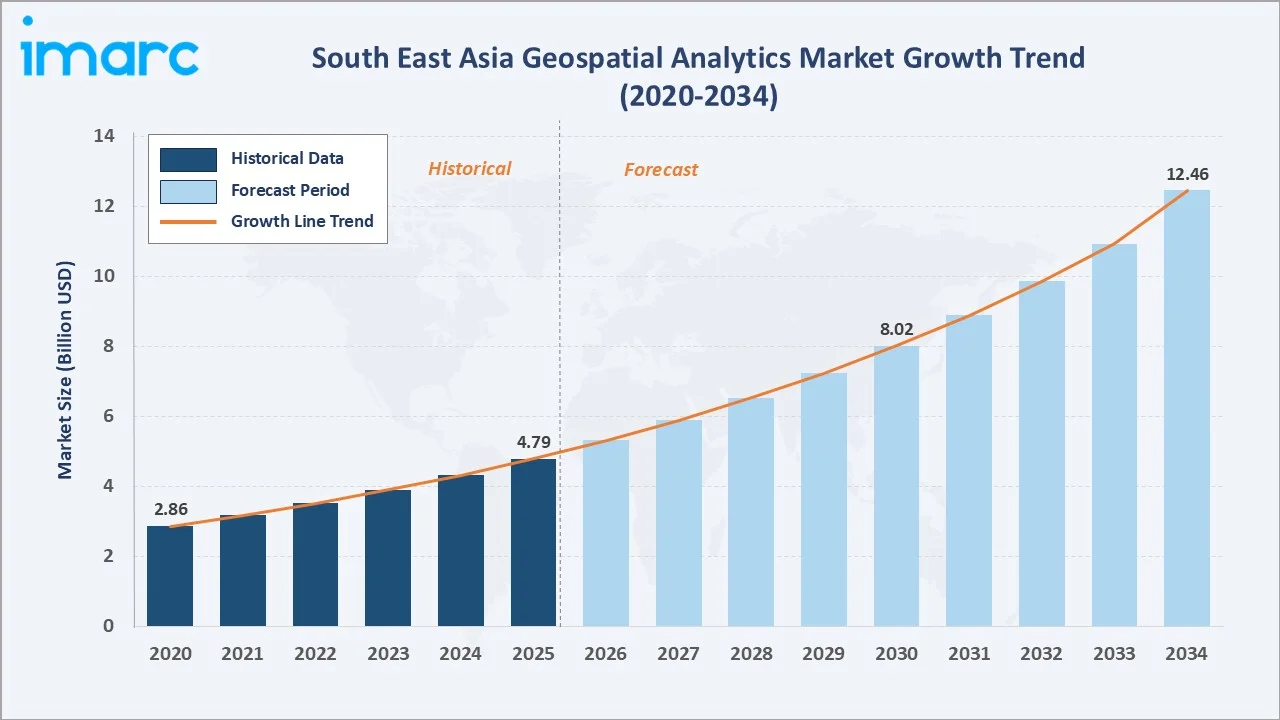
The South East Asia geospatial analytics market reached USD 4.79 Billion in 2025 and is projected to reach USD 12.46 Billion by 2034, growing at a CAGR of 10.86% during 2026-2034. The market is driven by growing innovations in satellite imaging, unmanned aerial vehicles, and sensor technologies, rising reliance on cloud computing, artificial intelligence, and machine learning, and increasing proliferation of location-based services.
The Solutions segment from the component breakup dominates at 62.7%. Large Enterprises lead the enterprise size breakup at 64.8%. Indonesia commands 24.8% of the national market share.
Market Snapshot
|
Metric |
Value |
|
Market Size (2025) |
USD 4.79 Billion |
|
Forecast Market Size (2034) |
USD 12.46 Billion |
|
CAGR (2026-2034) |
10.86% |
|
Base Year |
2025 |
|
Historical Period |
2020-2025 |
|
Forecast Period |
2026-2034 |
|
Dominant Component |
Solutions (62.7%, 2025) |
|
Dominant Enterprise Size |
Large Enterprises (64.8%, 2025) |
|
Leading Country |
Indonesia (24.8%, 2025) |
The market expanded from USD 2.86 Billion in 2020 to USD 4.79 Billion in 2025 - growing by nearly 68% in five years - anchored at USD 8.02 Billion in 2030 and forecast to reach USD 12.46 Billion by 2034. The COVID-19 pandemic accelerated digital transformation initiatives across the region as governments and enterprises invested in location intelligence to support pandemic response and remote operations, a trend that has continued to compound through the historical period.
To get more information on this market, Request Sample
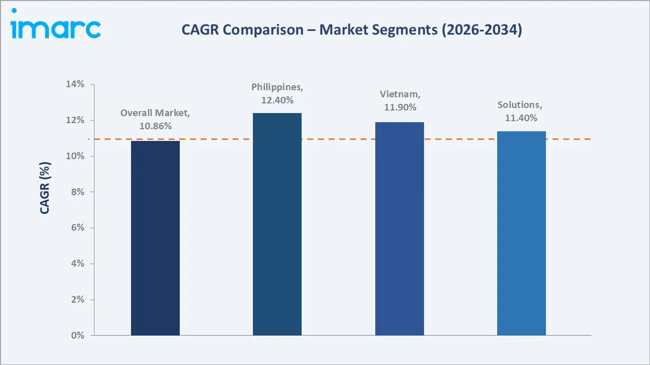
The Philippines grows fastest at approximately 12.4% CAGR as enterprises accelerate digital infrastructure investment from a smaller base. Solutions grows at approximately 11.4% CAGR as organizations increasingly invest in platform-based geospatial analytics capabilities.
Executive Summary
The South East Asia geospatial analytics market reached USD 4.79 Billion in 2025, representing one of the region's fastest-growing technology segments, driven by the structural shift toward data-driven decision-making across government and enterprise sectors. Geospatial analytics enables organizations to capture, manage, analyze, and visualize geographic data, empowering informed decisions in urban planning, disaster management, and resource optimization. The market is projected to reach USD 12.46 Billion by 2034.
The Solutions segment at 62.7% dominates by capturing software platforms, mapping tools, and analytical engines that organizations deploy to process geospatial data. Large Enterprises at 64.8% lead through their greater IT budgets, more complex operational footprints requiring location intelligence, and stronger capacity to invest in advanced geospatial infrastructure. Indonesia at 24.8% leads nationally through its vast archipelagic geography requiring extensive spatial data infrastructure, growing government digitalization initiatives, and expanding enterprise adoption across natural resources and urban planning sectors.
Key Market Insights
|
Insight |
Data |
|
Dominant Component |
Solutions - 62.7% share (2025) |
|
Dominant Enterprise Size |
Large Enterprises - 64.8% market share (2025) |
|
Leading Country |
Indonesia - 24.8% market share (2025) |
|
Market Opportunity |
AI-powered predictive analytics; satellite imagery democratization; smart city expansion; SME geospatial adoption; disaster management platforms |
Key Analytical Observations Supporting the Above Data:
- Solutions at 62.7%: The Solutions segment dominates as organizations increasingly invest in geospatial software platforms, mapping tools, and analytical engines to build in-house location intelligence capabilities rather than relying solely on outsourced services. Its scalable licensing structure and expanding functionality covering predictive modeling, visualization, and real-time data processing further reinforce segment demand. Continued technological refinement in AI-integrated platforms is sustaining upgrade cycles across the installed enterprise base.
- Large Enterprises at 64.8%: The Large Enterprises segment dominates due to greater IT budgets, more complex operational footprints spanning multiple geographic locations, and stronger capacity to invest in advanced geospatial infrastructure and specialized analytical talent. With regional digital transformation initiatives continuing to expand, large enterprise geospatial spending is generating substantial and sustained demand for solutions and services. Multinational corporations with regional operations across South East Asia are further expanding location intelligence investment.
- Indonesia at 24.8%: Indonesia dominates the geospatial analytics market due to its vast archipelagic geography requiring extensive spatial data infrastructure for governance, natural resource management, and disaster response. Strong government support for digital mapping initiatives and growing enterprise adoption across natural resources, agriculture, and urban planning sectors are generating substantial demand for geospatial analytics solutions and services across the country.
South East Asia Geospatial Analytics Market Overview
The South East Asia geospatial analytics market encompasses the capture, management, analysis, and visualization of geographic and spatial data, spanning descriptive, spatial, and predictive analytics approaches deployed across solutions and services delivery models to support urban planning, disaster management, and resource optimization applications.
The ecosystem integrates satellite and aerial data providers, geospatial software and analytics vendors, system integrators, local IT partners, cloud and data infrastructure providers, and regulatory bodies overseeing satellite data licensing and spatial data governance. Macroeconomic factors include rising digital transformation investment, expanding smart city initiatives, growing enterprise IT modernization budgets, and continued government support for national spatial data infrastructure development.
Market Dynamics
To evaluate market opportunities, Request Sample
Market Drivers
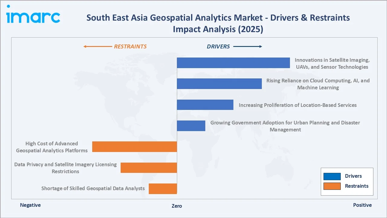
- Innovations in Satellite Imaging, UAVs, and Sensor Technologies: Growing innovations in satellite imaging, unmanned aerial vehicles, and sensor technologies across South East Asia are expanding the availability and quality of geospatial data available for enterprise and government analysis. This expanding data availability is translating into higher demand for advanced analytics platforms capable of processing increasingly detailed spatial datasets, widening the addressable market as sensor costs decline.
- Rising Reliance on Cloud Computing, AI, and Machine Learning: The growing integration of cloud computing, artificial intelligence, and machine learning into geospatial platforms is significantly enhancing processing power and analytical capabilities, enabling predictive modeling and pattern recognition. Enterprises are increasingly seeking cloud-based geospatial platforms that offer scalability and real-time data processing without heavy upfront infrastructure investment, generating consistent demand for specialized expertise.
- Increasing Proliferation of Location-Based Services: The rising use of location-based services for targeted marketing, location-based promotions, and optimized supply chain management is driving geospatial analytics demand across the retail and logistics sectors. Businesses are increasingly leveraging geospatial analytics to enhance customer engagement and streamline operational efficiency, a demand expected to sustain market growth well beyond the current forecast period.
- Growing Government Adoption for Urban Planning and Disaster Management: Government agencies across South East Asia are increasingly integrating geospatial analytics into public services and policy planning to address urbanization challenges and enhance disaster response capabilities. These government initiatives are widening geospatial analytics adoption beyond enterprise customers into public sector applications, positioning national spatial data infrastructure support as a durable growth driver.
Market Restraints
- High Cost of Advanced Geospatial Analytics Platforms: The high cost of advanced geospatial analytics platforms and satellite imagery licensing limits adoption among smaller organizations operating in price-sensitive regional markets. This cost barrier is particularly pronounced among small and medium-sized enterprises with limited technology budgets, causing platform adoption to lag several years behind larger, better-resourced enterprises.
- Data Privacy and Satellite Imagery Licensing Restrictions: Varying data privacy regulations and satellite imagery licensing restrictions across South East Asian countries constrain seamless cross-border geospatial data sharing and complicate multi-country analytics projects. This regulatory fragmentation creates a structural bottleneck limiting the pace of multinational geospatial projects, requiring sustained investment in region-specific compliance expertise.
- Shortage of Skilled Geospatial Data Analysts: A limited pool of trained geospatial data scientists and GIS specialists across South East Asia constrains project delivery capacity and extends implementation timelines for enterprise and government customers. This talent shortage creates meaningful capacity constraints for both global providers and local system integrators, extending project timelines and raising service costs across the industry.
Market Opportunities
- AI-Powered Predictive Analytics Expansion: The growing enterprise and government adoption of AI-powered predictive geospatial analytics is creating substantial demand for platforms capable of forecasting environmental, urban, and commercial trends. Organizations across the region are increasingly seeking geospatial infrastructure capable of supporting advanced predictive modeling at scale, positioning specialized providers to capture incremental demand.
- Democratization of Satellite Imagery Access: Declining costs of acquiring and processing high-resolution satellite imagery are democratizing geospatial data access, creating opportunities for SMEs and non-profit organizations to adopt location intelligence. This shift is particularly relevant as smaller organizations across the region seek to harness geospatial capabilities without significant upfront capital investment, favoring providers with simplified, cost-effective platforms.
Market Challenges
- Intensifying Price Competition Among Providers: The growing number of global and regional geospatial analytics providers is intensifying price competition, particularly for standardized mapping and visualization offerings with limited differentiation. This dynamic is compressing margins for providers while expanding market access for price-sensitive SME customers, making pricing and expertise investment an ongoing balance.
- Data Integration and Interoperability Complexity: Enterprises frequently encounter challenges integrating geospatial data from disparate sources and formats, creating implementation delays and client satisfaction challenges for service providers. This challenge is prompting providers to invest more heavily in data standardization and interoperability tooling as part of standard engagements, making seamless integration an important competitive differentiator.
Emerging Market Trends
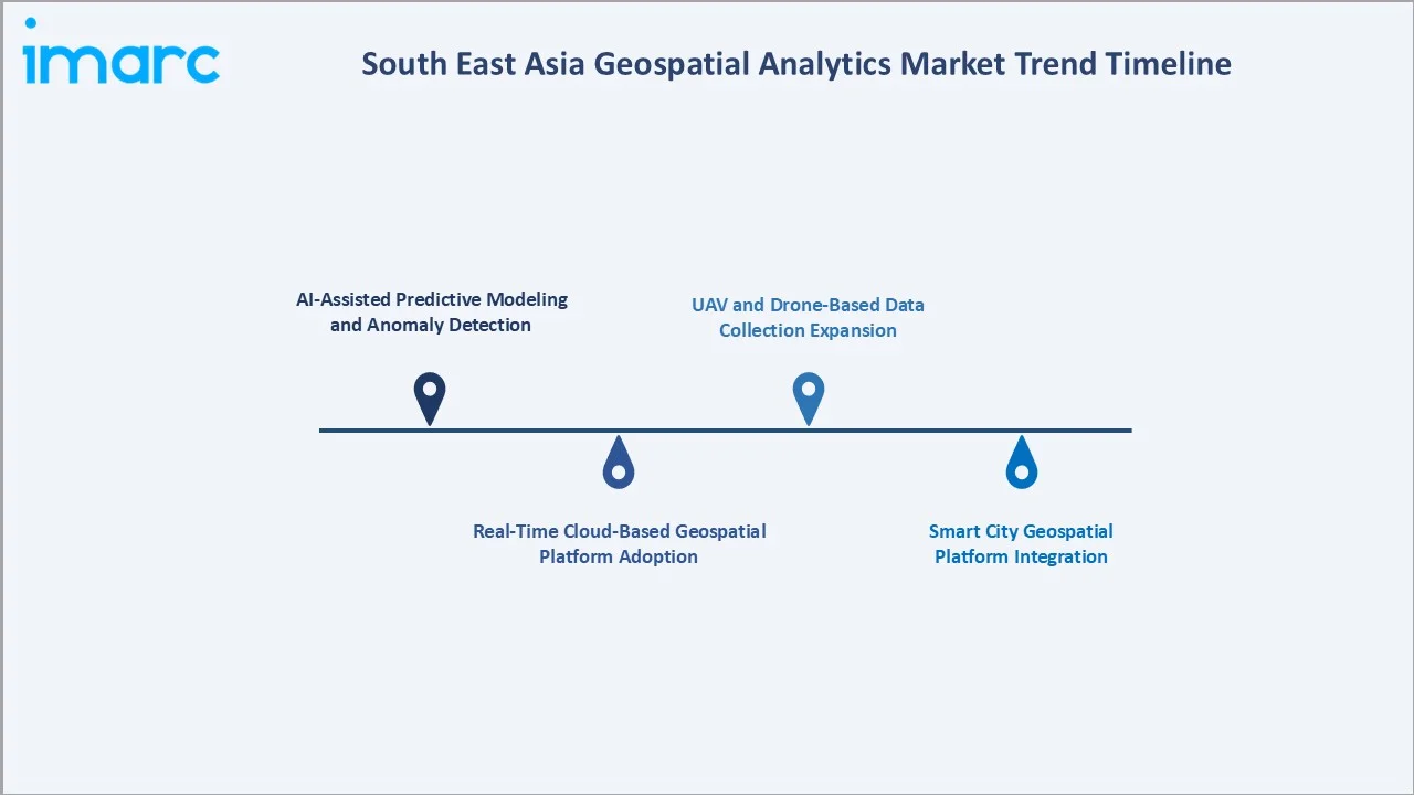
1. AI-Assisted Predictive Modeling and Anomaly Detection
Artificial intelligence integration into geospatial analytics platforms is enabling automated pattern recognition and anomaly detection, reducing manual analysis effort and improving decision accuracy. Leading regional providers are expanding AI-assisted geospatial tooling to accelerate insight delivery for enterprise and government customers. This technology is expected to become a standard feature across premium geospatial platforms as adoption accumulates over the forecast period.
2. Real-Time Cloud-Based Geospatial Platform Adoption
Real-time cloud-based geospatial platforms are emerging as organizations prioritize immediate access to location intelligence rather than batch-processed historical analysis. This design shift can enhance operational responsiveness, reduce infrastructure overhead, and simplify data access for enterprise customers. As providers expand validated cloud-native methodologies, wider adoption is expected across both large enterprises and government agencies.
3. UAV and Drone-Based Data Collection Expansion
UAV and drone-based data collection platforms are expanding fine-grained spatial data acquisition capabilities, offering enhanced resolution and reduced cost compared to traditional satellite imagery for localized applications. These platforms can improve data granularity and enable more frequent monitoring cycles for agriculture, construction, and infrastructure applications. As development matures, UAV-based data collection is expected to gain traction among large regional enterprises.
4. Smart City Geospatial Platform Integration
Geospatial platforms tailored to smart city applications are gaining prominence as governments seek integrated location intelligence for traffic management, utility monitoring, and urban planning. Their rapid expansion creates new procurement opportunities for comprehensive, government-focused geospatial services. As providers expand smart city-focused offerings, service providers benefit from a broadening customer base beyond traditional enterprise channels.
Industry Value Chain Analysis
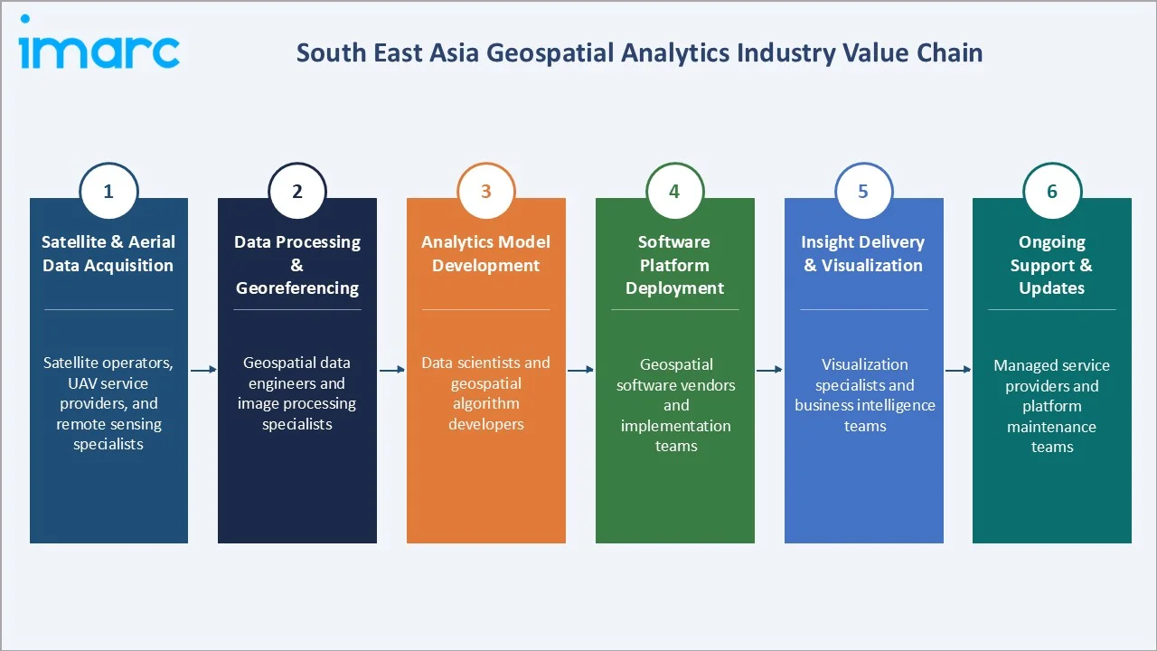
The South East Asia geospatial analytics value chain integrates satellite and aerial data acquisition, data processing and georeferencing, analytics model development, software platform deployment, insight delivery and visualization, and ongoing support and updates. The value chain's commercial architecture is anchored around enterprise and government procurement cycles, with system integrators and local IT partners playing an increasingly important role in supporting delivery capacity across the region.
|
Stage |
Key Participants |
|
Satellite & Aerial Data Acquisition |
Satellite operators, UAV service providers, and remote sensing specialists |
|
Data Processing & Georeferencing |
Geospatial data engineers and image processing specialists |
|
Analytics Model Development |
Data scientists and geospatial algorithm developers |
|
Software Platform Deployment |
Geospatial software vendors and implementation teams |
|
Insight Delivery & Visualization |
Visualization specialists and business intelligence teams |
|
Ongoing Support & Updates |
Managed service providers and platform maintenance teams |
The analytics model development stage remains the value chain's most technically demanding segment, requiring specialized data science and geospatial engineering expertise. The ongoing support and updates stage is experiencing growing importance as enterprises increasingly rely on continuous platform enhancement rather than static deployments.
Technology Landscape in the South East Asia Geospatial Analytics Industry
High-Resolution Satellite Imaging Technology
High-resolution satellite imaging technology offers detailed spatial data capture, enabling more accurate identification of land use patterns, infrastructure changes, and environmental conditions. These systems support improved analytical accuracy and reduced field verification requirements, making them the preferred choice for leading enterprise and government geospatial engagements. Their widespread adoption is accelerating replacement demand for lower-resolution legacy imaging sources across the region.
Cloud-Based Geospatial Platform Technology
Cloud-based geospatial platform technology offers enhanced scalability, real-time data processing, and reduced infrastructure overhead compared to on-premises deployments. These platforms provide reliable performance across large-scale spatial datasets, supporting their broad adoption among large enterprises and government agencies with complex analytical requirements across South East Asia.
AI-Integrated Geospatial Analytics Tools
Numerous leading regional providers expanded pilot programs for AI-assisted geospatial analytics aimed at improving predictive accuracy and reducing manual analysis effort. These tools use machine learning algorithms trained on large spatial datasets to flag patterns and anomalies in real time, supporting analysts in reducing decision-making delays. Continued validation is expected to drive broader adoption of AI-integrated geospatial tools across premium and mid-tier platform offerings.
Market Segmentation Analysis
The report covers the following segments:
|
Segment Category |
Leading Segment |
Market Share |
Year |
|
Component |
Solutions |
62.7% |
2025 |
|
Type |
🔒 |
🔒 |
2025 |
|
Technology |
🔒 |
🔒 |
2025 |
|
Enterprise Size |
Large Enterprises |
64.8% |
2025 |
|
Deployment Mode |
🔒 |
🔒 |
2025 |
|
Vertical |
🔒 |
🔒 |
2025 |
|
Country |
Indonesia |
24.8% |
2025 |

By Component
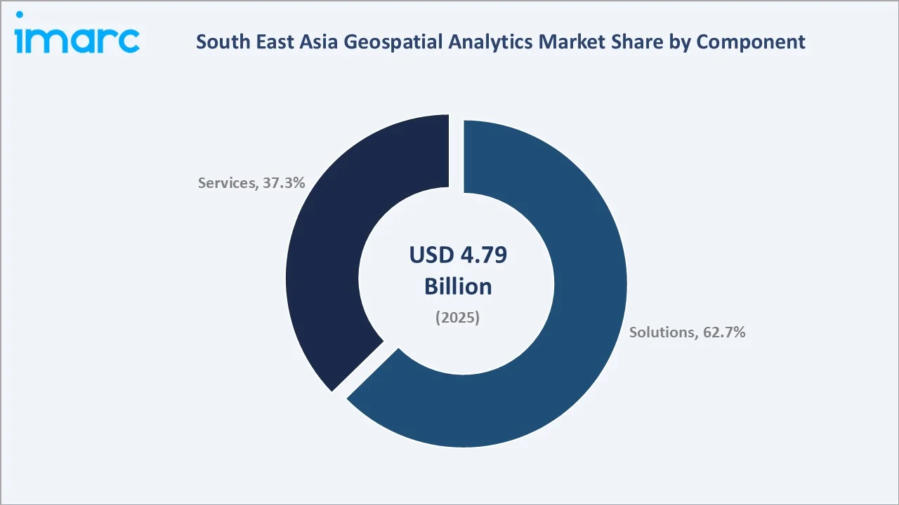
The Solutions segment leads at 62.7% in 2025, encompassing geospatial software platforms, mapping tools, and analytical engines, the most commercially significant and highest-revenue category in the South East Asia geospatial analytics market.
To access detailed market analysis, Request Sample
Services at 37.3% capture consulting, implementation, and managed support engagements. These services typically complement solution deployments, helping organizations configure, integrate, and optimize geospatial platforms as their analytical requirements mature and expand over time.
By Enterprise Size
Large Enterprises dominate enterprise size at 64.8%, reflecting their greater IT budgets, more complex operational footprints, and stronger capacity to invest in advanced geospatial infrastructure and specialized analytical talent.
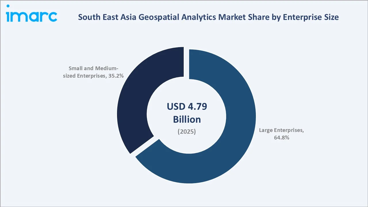
Small and Medium-sized Enterprises account for 35.2%, gaining share as declining satellite imagery costs and simplified cloud-based platforms lower barriers to geospatial analytics adoption. This segment is expected to grow steadily as digital transformation extends beyond large corporate customers across the region.
Regional Market Insights
|
Country |
Share (2025) |
Key Market Drivers & Characteristics |
|
Indonesia |
24.8% |
Driven by vast archipelagic geography requiring extensive spatial data infrastructure and growing government digitalization initiatives |
|
Singapore |
20.9% |
Driven by advanced digital infrastructure, smart city leadership, and concentration of regional corporate headquarters |
|
Malaysia |
16.4% |
Supported by government-led digital transformation initiatives and expanding natural resources sector adoption |
|
Thailand |
14.2% |
Driven by growing urban planning and disaster management applications and expanding agricultural technology adoption |
|
Vietnam |
10.8% |
Emerging with strong technology sector growth and increasing foreign direct investment in digital infrastructure |
|
Philippines |
8.7% |
Supported by expanding disaster resilience initiatives given the country's exposure to natural hazards |
|
Others |
4.2% |
Includes remaining South East Asian markets with developing geospatial infrastructure and gradual digital adoption |
Indonesia, at 24.8%, leads through its archipelagic geography and growing government digitalization initiatives. Singapore, at 20.9%, reflects advanced digital infrastructure and smart city leadership across the country's compact urban environment.
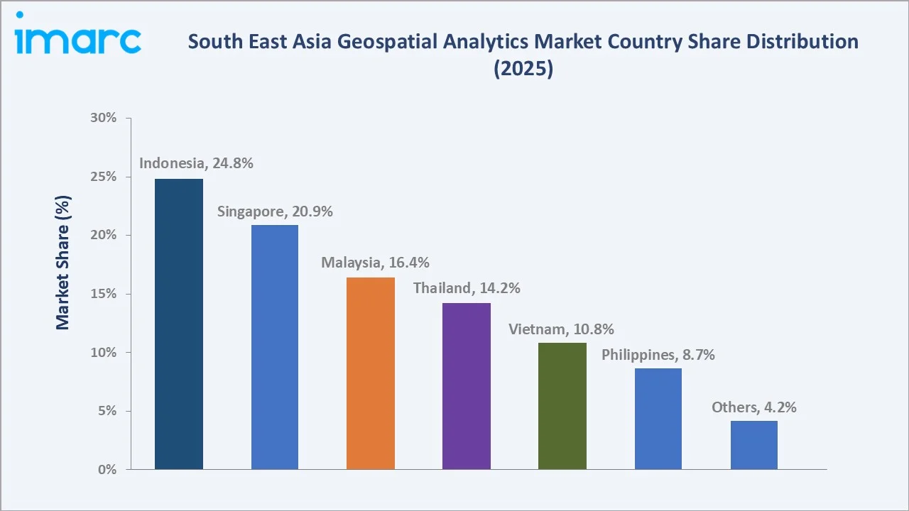
Malaysia, at 16.4%, benefits from government-led digital transformation initiatives and expanding natural resources adoption. Thailand, Vietnam, and the Philippines collectively represent emerging markets as regional infrastructure investment continues to expand digital access across underserved segments.
Competitive Landscape
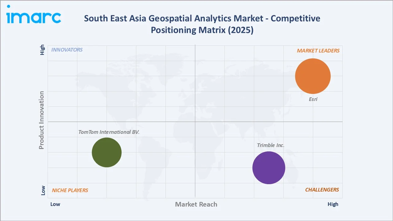
The South East Asia geospatial analytics market competitive landscape is moderately concentrated, comprising established global geospatial software vendors and enterprise technology firms alongside specialized regional system integrators competing on technical expertise, service reach, and local regulatory knowledge suited to the region's fragmented compliance environment.
|
Company Name |
Key Products |
Market Position |
Core Strength |
|
Esri |
ARCGIS |
Market Leader |
Leading global GIS software provider with extensive regional government and enterprise adoption across South East Asia |
|
Trimble Inc. |
Geospatial and positioning solutions |
Strong Challenger |
Diversified surveying and geospatial analytics portfolio serving infrastructure and construction sectors |
|
TomTom International BV. |
TomTom Maps, TomTom location APIs |
Niche Player |
Focused mapping and location data offerings for navigation and logistics applications |
Key players include Esri, Trimble Inc., TomTom International BV., and others.
Key Company Profiles
Esri
Esri, is a global leader in geographic information system software, maintaining a strong presence in the South East Asia geospatial analytics market through its comprehensive ArcGIS platform ecosystem.
- Key Products: ArcGIS Pro, ArcGIS Online, ArcGIS Enterprise.
- Strategic Focus: Expanding AI-integrated geospatial analytics capabilities and strengthening government partnership programs across major South East Asian markets. The company is also investing in regional certification programs, including additional technical training centers, to build a larger pool of ArcGIS-certified specialists.
TomTom International BV.
TomTom International BV. is a Netherlands-based location technology company with an established presence in the South East Asia geospatial analytics market through its digital mapping and location data platform offerings.
- Key Products: TomTom Maps, TomTom location APIs
- Strategic Focus: Strengthening its next-generation Orbis mapping platform and expanding location API offerings across South East Asia's navigation, logistics, and enterprise mobility markets. The company is investing in expanding its regional developer ecosystem to reduce onboarding friction and improve platform responsiveness for regional enterprise customers. TomTom's continued regional expansion strategy positions it to capture incremental share as enterprise location-intelligence adoption accelerates.
Market Concentration Analysis
The South East Asia geospatial analytics market is moderately concentrated at the software platform level, with the key players collectively accounting for a significant share of underlying platform revenue. Services delivery remains more fragmented, with global consulting firms, regional system integrators, and specialized local GIS firms each capturing meaningful shares of implementation and support engagements. Market concentration at the services layer is expected to gradually shift as regional system integrators expand technical capacity and compliance expertise across the forecast period.
Investment & Growth Opportunities
Highest Growth Segments
The Philippines (approximately 12.4% CAGR), Vietnam (approximately 11.9% CAGR), Solutions (approximately 11.4% CAGR), AI-powered predictive analytics services, and SME-focused simplified geospatial packages represent the highest-growth investment vectors through 2034.
Emerging Investment Opportunities
SME-focused geospatial packages represent the market's fastest-growing emerging opportunity, as declining satellite imagery costs and simplified onboarding expand adoption among the region's large underserved small and medium-sized enterprise base through 2034.
Investment Themes
- AI-Integrated Predictive Analytics Platform Development Through 2034: AI-assisted geospatial analytics represents a meaningful investment opportunity for providers seeking to differentiate premium enterprise and government offerings. Companies that achieve validated accuracy improvements in predictive modeling and anomaly detection can create a durable competitive advantage in the high-value procurement segment.
- Regional System Integrator Capacity Expansion Capturing SME and Government Growth: South East Asia's fragmented regulatory landscape and large underserved SME base create a structurally growing addressable market for regional system integrators offering localized compliance expertise and simplified geospatial packages.
Future Market Outlook (2026-2034)
The South East Asia geospatial analytics market is projected to grow from USD 4.79 Billion in 2025 to USD 12.46 Billion by 2034, delivering a 10.86% CAGR over the forecast period. The market's anchor value of USD 8.02 Billion in 2030 represents a significant enterprise and government adoption inflection point, with AI-assisted predictive analytics, real-time cloud-based platforms, and SME-focused packages expected to see wider adoption. Rising digital transformation investment and expanding smart city infrastructure together define a durable growth trajectory through 2034.
Research Methodology
Primary Research
Primary research comprised structured interviews with enterprise IT decision-makers, geospatial analytics consultants, government mapping agency officials, and regional system integrator executives across South East Asia's major technology markets.
Secondary Research
Secondary research encompassed company annual reports, national spatial data infrastructure authority publications, industry association data, and peer-reviewed enterprise geospatial adoption studies. Over 50 secondary sources were reviewed.
Forecasting Models
Market revenue forecasts were developed using a deployment-volume-based bottom-up model incorporating enterprise and government IT modernization spending by country, average platform and service engagement scope by enterprise size, and recurring subscription revenue per deployed geospatial solution across the forecast period.
South East Asia Geospatial Analytics Market Report Coverage:
| Report Features | Details |
|---|---|
| Base Year of the Analysis | 2025 |
| Historical Period | 2020-2025 |
| Forecast Period | 2026-2034 |
| Units | Billion USD |
| Scope of the Report |
Exploration of Historical and Forecast Trends, Industry Catalysts and Challenges, Segment-Wise Historical and Predictive Market Assessment:
|
| Components Covered | Solutions, Services |
| Types Covered | Surface and Field Analytics, Network and Location Analytics, Geovisualization, Others |
| Technologies Covered | Remote Sensing, GIS, GPS, Others |
| Enterprise Sizes Covered | Large Enterprises, Small and Medium-sized Enterprises |
| Deployment Modes Covered | On-premises, Cloud-based |
| Verticals Covered | Automotive, Energy and Utilities, Government, Defense and Intelligence, Smart Cities, Insurance, Natural Resources, Others |
| Countries Covered | Indonesia, Thailand, Singapore, Philippines, Vietnam, Malaysia, Others |
| Companies Covered | Esri, Trimble Inc., TomTom International BV., etc. |
| Customization Scope | 10% Free Customization |
| Post-Sale Analyst Support | 10-12 Weeks |
| Delivery Format | PDF and Excel through Email (We can also provide the editable version of the report in PPT/Word format on special request) |
Key Benefits for Stakeholders:
- IMARC’s industry report offers a comprehensive quantitative analysis of various market segments, historical and current market trends, market forecasts, and dynamics of the South East Asia geospatial analytics market from 2020-2034.
- The research report provides the latest information on the market drivers, challenges, and opportunities in the South East Asia geospatial analytics market.
- Porter's five forces analysis assist stakeholders in assessing the impact of new entrants, competitive rivalry, supplier power, buyer power, and the threat of substitution. It helps stakeholders to analyze the level of competition within the South East Asia geospatial analytics industry and its attractiveness.
- A competitive landscape allows stakeholders to understand their competitive environment and provides an insight into the current positions of key players in the market.
Frequently Asked Questions About the South East Asia Geospatial Analytics Market Report
The South East Asia geospatial analytics market reached USD 4.79 Billion in 2025, driven by Solutions dominant at 62.7%, Large Enterprises leading enterprise size at 64.8%, and Indonesia commanding 24.8% market share through its vast archipelagic geography.
The market grows at 10.86% CAGR during 2026-2034, reaching USD 12.46 Billion by 2034, reflecting rising satellite imaging innovation, growing AI and cloud computing reliance, and expanding location-based services proliferation.
Solutions lead at 62.7%, capturing geospatial software platforms and analytical engines, growing at approximately 11.4% CAGR through expanding platform-based capability investment and recurring enterprise engagement demand.
Large Enterprises lead at 64.8% through greater IT budgets and more complex operational footprints requiring location intelligence, driving structured and well-resourced engagement demand across the region.
Indonesia leads at 24.8% through its vast archipelagic geography, growing government digitalization initiatives, and expanding enterprise adoption across natural resources and urban planning sectors.
Leading companies include Esri, Trimble Inc., TomTom International BV., and others.
The market is projected to reach approximately USD 8.02 Billion by 2030, with AI-assisted predictive analytics becoming more standard for enterprise deployments, real-time cloud-based platforms gaining broader adoption, and SME-focused geospatial packages expanding across the region.
Three priority opportunities: AI-integrated predictive analytics platform development, regional system integrator capacity expansion for SME and government segments, and smart city geospatial platform integration services.
Need more help?
- Speak to our experienced analysts for insights on the current market scenarios.
- Include additional segments and countries to customize the report as per your requirement.
- Gain an unparalleled competitive advantage in your domain by understanding how to utilize the report and positively impacting your operations and revenue.
- For further assistance, please connect with our analysts.
 Request Customization
 Speak to an Analyst
 Request Brochure
 Inquire Before Buying
Benefits of Customization
- Personalize this research
- Triangulate with your data
- Get data as per your format and definition
- Gain a deeper dive into a specific application, geography, customer, or competitor
- Any level of personalization
Get in Touch With Us
UNITED STATES
Phone: +1-201-971-6302
INDIA
Phone: +91-120-433-0800
UNITED KINGDOM
Phone: +44-753-714-6104
Email: [email protected]
Client Testimonials




.webp)




.webp)













Related Reports

Choose your plan
*Please note that the prices mentioned below are starting prices for each bundle type. Kindly contact our team for further details.*
Single User License
- 1 User License, Access on 2 Devices
- PDF Report + Excel Dataset (Password Protected)
- Lifetime Access
- No Printing Rights
- 10% Free Report Customization
- 10–12 Weeks of Analyst Support
Five User License
- Access for 5 Users, 2 Devices per User
- PDF Report + Excel Dataset (Password Protected)
- Lifetime Access
- Dedicated Account Manager
- 12–14 Weeks of Analyst Support
- No Printing Rights
- 15% Free Report Customization
- 25% Discount on Your Next Purchase
Corporate User License
- Unlimited User Access (Within Your Organization)
- PDF Report + Excel Dataset
- Lifetime Access
- Dedicated Account Manager
- 14–20 Weeks of Analyst Support
- No Printing Rights
- 20% Free Report Customization
- 30% Discount on Your Next Purchase
Essential Insights
What's included:
3 reports
- Lifetime Access
- PDF Reports
- Excel Datasets
- 2 Weeks of Free Analyst Support
- 2 User Licenses
- Access on 2 Devices
- Printing Rights
- Complimentary PowerPoint (PPT) Version
- Complimentary License Upgrade
Professional Access
What's included:
5 reports
- Lifetime Access
- PDF Reports
- Excel Datasets
- 8 Weeks of Free Analyst Support
- 2 User Licenses
- Access on 2 Devices
- Printing Rights
- Complimentary PowerPoint (PPT) Version
- Complimentary License Upgrade
Business Advantage
What's included:
8 reports
- Lifetime Access
- PDF Reports
- Excel Datasets
- 14 Weeks of Free Analyst Support
- 2 User Licenses
- Access on 2 Devices
- Printing Rights
- Complimentary PowerPoint (PPT) Version
- Complimentary License Upgrade
Enterprise Intelligence
What's included:
10 reports
- Lifetime Access
- PDF Reports
- Excel Datasets
- 20 Weeks of Free Analyst Support
- 2 User Licenses
- Access on 2 Devices
- Printing Rights
- Complimentary PowerPoint (PPT) Version
- Complimentary License Upgrade